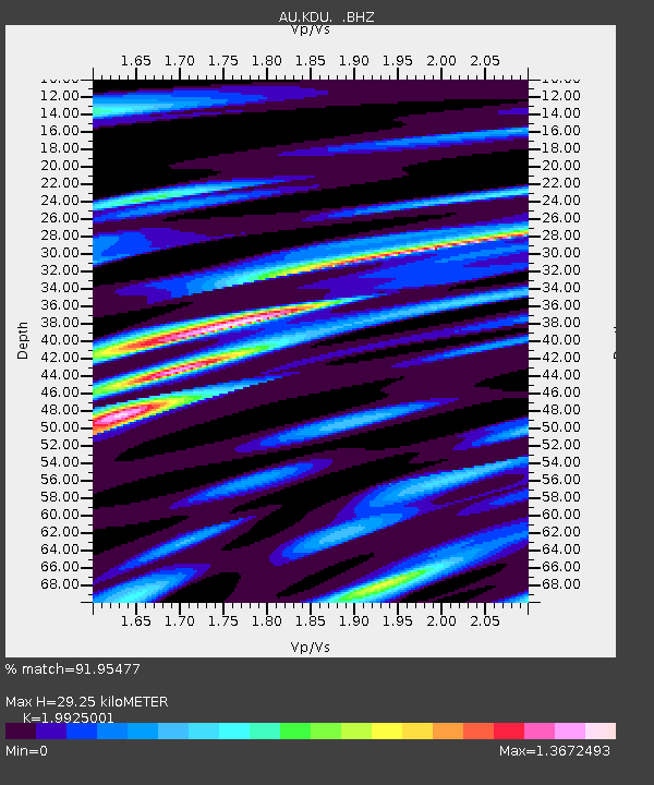
KDU Kakadu, NT - Earthquake Result Viewer

Earthquake location: Southern Sumatra, Indonesia
Earthquake latitude/longitude: -3.3/100.6
Earthquake time(UTC): 2012/09/14 (258) 04:51:47 GMT
Earthquake Depth: 19 km
Earthquake Magnitude: 6.1 MB, 6.3 MS, 6.2 MW, 6.2 MW
Earthquake Catalog/Contributor: WHDF/NEIC
Network: AU Australian Seismological Centre
Station: KDU Kakadu, NT
Lat/Lon: 12.69 S/132.47 E
Elevation: 46 m
Distance: 32.9 deg
Az: 108.275 deg
Baz: 283.736 deg
Ray Param: 0.07844898
Estimated Moho Depth: 29.25 km
Estimated Crust Vp/Vs: 1.99
Assumed Crust Vp: 6.61 km/s
Estimated Crust Vs: 3.317 km/s
Estimated Crust Poisson's Ratio: 0.33
Radial Match: 91.95477 %
Radial Bump: 400
Transverse Match: 75.64743 %
Transverse Bump: 400
SOD ConfigId: 476835
Insert Time: 2013-02-22 19:07:09.603 +0000
GWidth: 2.5
Max Bumps: 400
Tol: 0.001

Signal To Noise

ChannelStoNSTALTA
AU:KDU: :BHZ:20120914T04:57:49.070Z8.4499211.5045047E-61.7804958E-7
AU:KDU: :BHN:20120914T04:57:49.070Z3.62567235.1171145E-71.411356E-7
AU:KDU: :BHE:20120914T04:57:49.070Z8.0970959.144333E-71.1293351E-7
Arrivals
Ps4.7 SECOND
PpPs12 SECOND
PsPs/PpSs17 SECOND