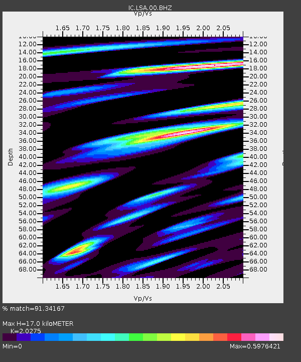
LSA Tibet, China - Earthquake Result Viewer
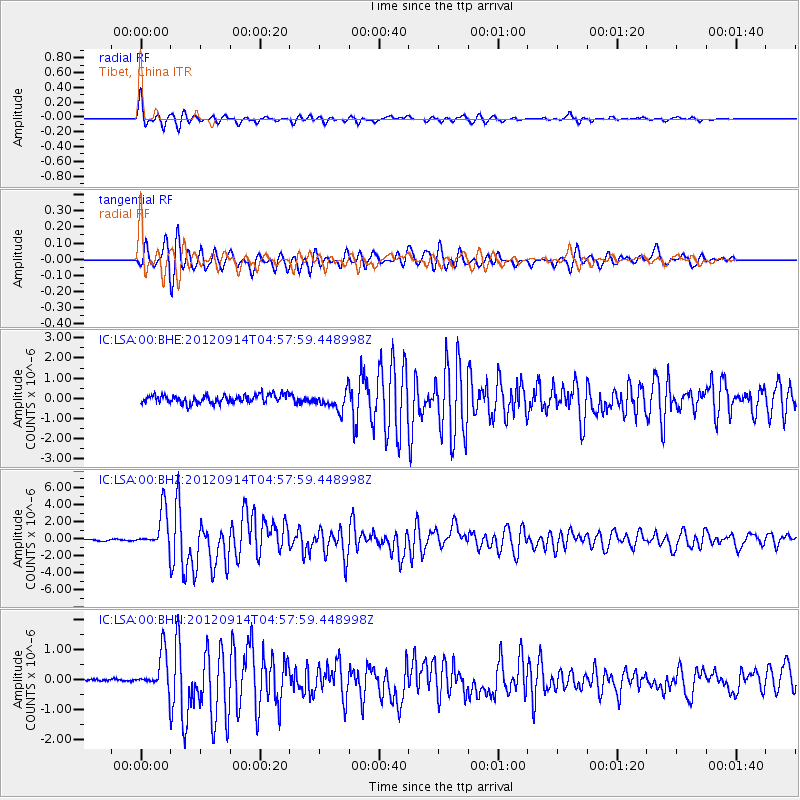
Earthquake location: Southern Sumatra, Indonesia
Earthquake latitude/longitude: -3.3/100.6
Earthquake time(UTC): 2012/09/14 (258) 04:51:47 GMT
Earthquake Depth: 19 km
Earthquake Magnitude: 6.1 MB, 6.3 MS, 6.2 MW, 6.2 MW
Earthquake Catalog/Contributor: WHDF/NEIC
Network: IC New China Digital Seismograph Network
Station: LSA Tibet, China
Lat/Lon: 29.70 N/91.13 E
Elevation: 3660 m
Distance: 34.1 deg
Az: 345.198 deg
Baz: 162.953 deg
Ray Param: 0.07790021
Estimated Moho Depth: 17.0 km
Estimated Crust Vp/Vs: 2.03
Assumed Crust Vp: 6.514 km/s
Estimated Crust Vs: 3.213 km/s
Estimated Crust Poisson's Ratio: 0.34
Radial Match: 91.34167 %
Radial Bump: 359
Transverse Match: 82.59982 %
Transverse Bump: 400
SOD ConfigId: 476835
Insert Time: 2013-02-22 19:07:54.067 +0000
GWidth: 2.5
Max Bumps: 400
Tol: 0.001

Signal To Noise

ChannelStoNSTALTA
IC:LSA:00:BHZ:20120914T04:57:59.448998Z37.3417852.2573843E-66.045196E-8
IC:LSA:00:BHN:20120914T04:57:59.448998Z19.3311046.473724E-73.3488643E-8
IC:LSA:00:BHE:20120914T04:57:59.448998Z2.2330784.5674497E-72.0453605E-7
Arrivals
Ps2.9 SECOND
PpPs7.4 SECOND
PsPs/PpSs10 SECOND