You are here: Home > Network List > PF - Volcanologic Network of Piton de Fournaise-OVPF Stations List
> Station FRE Station Sismologique des Fonds de la Riviere de l'Est > Earthquake Result Viewer
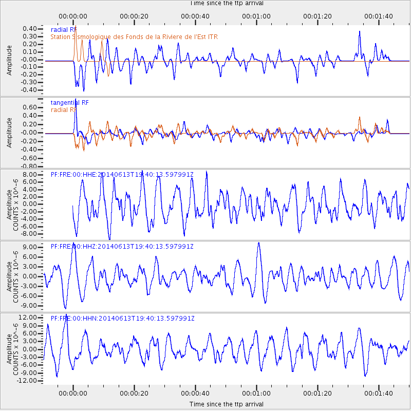
FRE Station Sismologique des Fonds de la Riviere de l'Est - Earthquake Result Viewer
*The percent match for this event was below the threshold and hence no stack was calculated.
| Earthquake location: |
Southern Mid-Atlantic Ridge |
| Earthquake latitude/longitude: |
-46.0/-13.9 |
| Earthquake time(UTC): |
2014/06/13 (164) 19:30:30 GMT |
| Earthquake Depth: |
10 km |
| Earthquake Magnitude: |
5.7 MB, 5.6 MWB, 5.8 MWC |
| Earthquake Catalog/Contributor: |
NEIC PDE/NEIC COMCAT |
|
| Network: |
PF Volcanologic Network of Piton de Fournaise-OVPF |
| Station: |
FRE Station Sismologique des Fonds de la Riviere de l'Est |
| Lat/Lon: |
21.20 S/55.70 E |
| Elevation: |
1775 m |
|
| Distance: |
61.0 deg |
| Az: |
91.096 deg |
| Baz: |
228.288 deg |
| Ray Param: |
$rayparam |
*The percent match for this event was below the threshold and hence was not used in the summary stack. |
|
| Radial Match: |
54.665096 % |
| Radial Bump: |
400 |
| Transverse Match: |
50.56346 % |
| Transverse Bump: |
400 |
| SOD ConfigId: |
3390531 |
| Insert Time: |
2019-04-12 06:16:16.352 +0000 |
| GWidth: |
2.5 |
| Max Bumps: |
400 |
| Tol: |
0.001 |
|
Signal To Noise
| Channel | StoN | STA | LTA |
| PF:FRE:00:HHZ:20140613T19:40:13.597991Z | 2.0725067 | 5.9126337E-6 | 2.85289E-6 |
| PF:FRE:00:HHN:20140613T19:40:13.597991Z | 1.3731896 | 4.803294E-6 | 3.4979105E-6 |
| PF:FRE:00:HHE:20140613T19:40:13.597991Z | 0.9547406 | 4.002805E-6 | 4.1925578E-6 |
| Arrivals |
| Ps | |
| PpPs | |
| PsPs/PpSs | |


