You are here: Home > Network List > CI - Caltech Regional Seismic Network Stations List
> Station FUR Furnace Creek, CA, USA > Earthquake Result Viewer
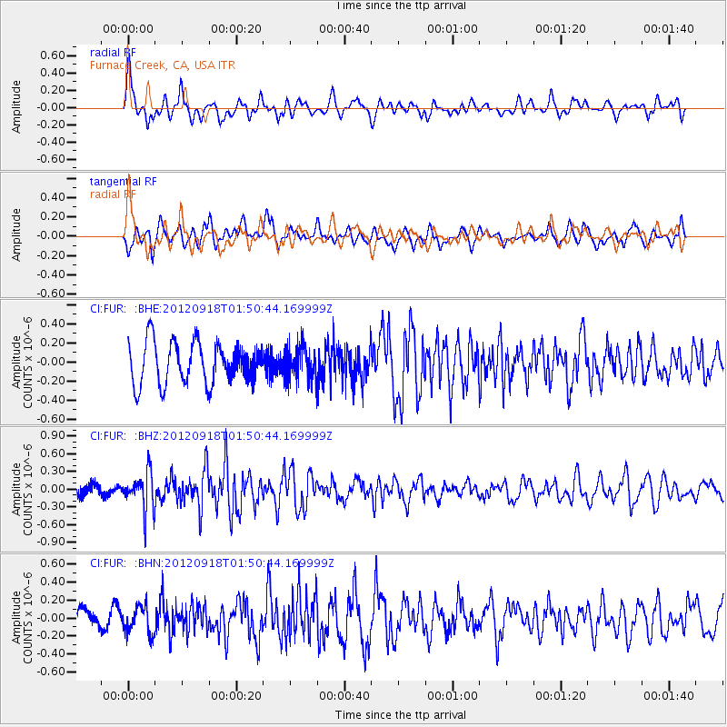
FUR Furnace Creek, CA, USA - Earthquake Result Viewer
*The percent match for this event was below the threshold and hence no stack was calculated.
| Earthquake location: |
Kodiak Island Region, Alaska |
| Earthquake latitude/longitude: |
56.9/-154.1 |
| Earthquake time(UTC): |
2012/09/18 (262) 01:44:50 GMT |
| Earthquake Depth: |
39 km |
| Earthquake Magnitude: |
5.5 MB, 4.7 MS, 5.2 MW, 5.1 MW |
| Earthquake Catalog/Contributor: |
WHDF/NEIC |
|
| Network: |
CI Caltech Regional Seismic Network |
| Station: |
FUR Furnace Creek, CA, USA |
| Lat/Lon: |
36.47 N/116.86 W |
| Elevation: |
-37.0 m |
|
| Distance: |
32.2 deg |
| Az: |
113.48 deg |
| Baz: |
321.415 deg |
| Ray Param: |
$rayparam |
*The percent match for this event was below the threshold and hence was not used in the summary stack. |
|
| Radial Match: |
59.836422 % |
| Radial Bump: |
400 |
| Transverse Match: |
64.35109 % |
| Transverse Bump: |
400 |
| SOD ConfigId: |
476835 |
| Insert Time: |
2013-02-22 19:16:35.214 +0000 |
| GWidth: |
2.5 |
| Max Bumps: |
400 |
| Tol: |
0.001 |
|
Signal To Noise
| Channel | StoN | STA | LTA |
| CI:FUR: :BHZ:20120918T01:50:44.169999Z | 2.9424582 | 3.226128E-7 | 1.09640574E-7 |
| CI:FUR: :BHN:20120918T01:50:44.169999Z | 1.1094277 | 1.5561132E-7 | 1.402627E-7 |
| CI:FUR: :BHE:20120918T01:50:44.169999Z | 0.8148372 | 1.7628656E-7 | 2.1634574E-7 |
| Arrivals |
| Ps | |
| PpPs | |
| PsPs/PpSs | |


