You are here: Home > Network List > TA - USArray Transportable Network (new EarthScope stations) Stations List
> Station Y22D IRIS PASSCAL Instrument Center, Socorro, NM, USA > Earthquake Result Viewer
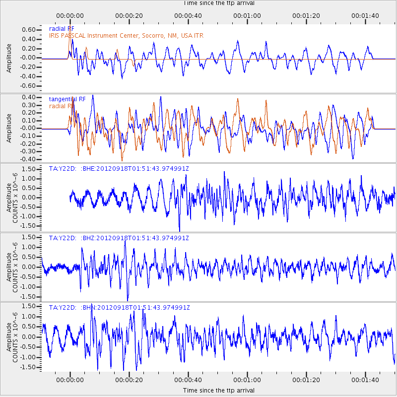
Y22D IRIS PASSCAL Instrument Center, Socorro, NM, USA - Earthquake Result Viewer
*The percent match for this event was below the threshold and hence no stack was calculated.
| Earthquake location: |
Kodiak Island Region, Alaska |
| Earthquake latitude/longitude: |
56.9/-154.1 |
| Earthquake time(UTC): |
2012/09/18 (262) 01:44:50 GMT |
| Earthquake Depth: |
39 km |
| Earthquake Magnitude: |
5.5 MB, 4.7 MS, 5.2 MW, 5.1 MW |
| Earthquake Catalog/Contributor: |
WHDF/NEIC |
|
| Network: |
TA USArray Transportable Network (new EarthScope stations) |
| Station: |
Y22D IRIS PASSCAL Instrument Center, Socorro, NM, USA |
| Lat/Lon: |
34.08 N/106.92 W |
| Elevation: |
1436 m |
|
| Distance: |
39.1 deg |
| Az: |
105.216 deg |
| Baz: |
320.41 deg |
| Ray Param: |
$rayparam |
*The percent match for this event was below the threshold and hence was not used in the summary stack. |
|
| Radial Match: |
44.79719 % |
| Radial Bump: |
400 |
| Transverse Match: |
56.62687 % |
| Transverse Bump: |
400 |
| SOD ConfigId: |
476835 |
| Insert Time: |
2013-02-22 19:22:47.980 +0000 |
| GWidth: |
2.5 |
| Max Bumps: |
400 |
| Tol: |
0.001 |
|
Signal To Noise
| Channel | StoN | STA | LTA |
| TA:Y22D: :BHZ:20120918T01:51:43.974991Z | 2.6149762 | 3.9373467E-7 | 1.5056912E-7 |
| TA:Y22D: :BHN:20120918T01:51:43.974991Z | 1.0045567 | 3.339466E-7 | 3.324318E-7 |
| TA:Y22D: :BHE:20120918T01:51:43.974991Z | 2.0395682 | 6.24035E-7 | 3.0596428E-7 |
| Arrivals |
| Ps | |
| PpPs | |
| PsPs/PpSs | |


