You are here: Home > Network List > YT07 - POLENET Stations List
> Station UNGL UNGL > Earthquake Result Viewer
UNGL UNGL - Earthquake Result Viewer
| Earthquake location: |
Southern Mid-Atlantic Ridge |
| Earthquake latitude/longitude: |
-46.0/-13.9 |
| Earthquake time(UTC): |
2014/06/13 (164) 19:30:30 GMT |
| Earthquake Depth: |
10 km |
| Earthquake Magnitude: |
5.7 MB, 5.6 MWB, 5.8 MWC |
| Earthquake Catalog/Contributor: |
NEIC PDE/NEIC COMCAT |
|
| Network: |
YT POLENET |
| Station: |
UNGL UNGL |
| Lat/Lon: |
79.77 S/82.52 W |
| Elevation: |
745 m |
|
| Distance: |
41.3 deg |
| Az: |
194.602 deg |
| Baz: |
79.414 deg |
| Ray Param: |
0.0738709 |
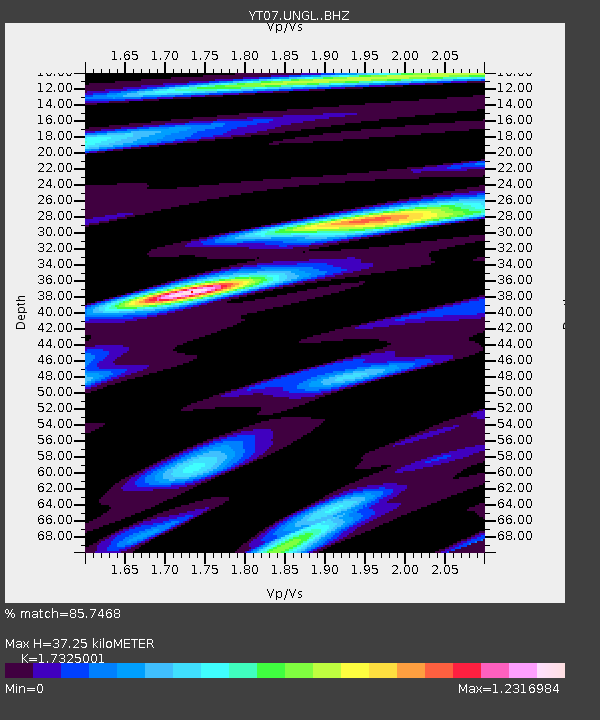
| Estimated Moho Depth: |
37.25 km |
| Estimated Crust Vp/Vs: |
1.73 |
| Assumed Crust Vp: |
6.182 km/s |
| Estimated Crust Vs: |
3.568 km/s |
| Estimated Crust Poisson's Ratio: |
0.25 |
|
| Radial Match: |
85.7468 % |
| Radial Bump: |
379 |
| Transverse Match: |
56.55796 % |
| Transverse Bump: |
400 |
| SOD ConfigId: |
3390531 |
| Insert Time: |
2019-04-12 06:17:58.764 +0000 |
| GWidth: |
2.5 |
| Max Bumps: |
400 |
| Tol: |
0.001 |
|

Signal To Noise
| Channel | StoN | STA | LTA |
| YT:UNGL: :BHZ:20140613T19:37:44.949004Z | 4.6083117 | 7.093198E-7 | 1.5392183E-7 |
| YT:UNGL: :BHN:20140613T19:37:44.949004Z | 2.603062 | 1.8871138E-7 | 7.249593E-8 |
| YT:UNGL: :BHE:20140613T19:37:44.949004Z | 2.827272 | 3.3626574E-7 | 1.1893647E-7 |
| Arrivals |
| Ps | 4.7 SECOND |
| PpPs | 15 SECOND |
| PsPs/PpSs | 20 SECOND |


