You are here: Home > Network List > G - GEOSCOPE Stations List
> Station WUS Wushi, Xinjiang Uygur, China > Earthquake Result Viewer
WUS Wushi, Xinjiang Uygur, China - Earthquake Result Viewer
| Earthquake location: |
Kuril Islands |
| Earthquake latitude/longitude: |
45.4/151.6 |
| Earthquake time(UTC): |
1999/05/08 (128) 19:44:35 GMT |
| Earthquake Depth: |
63 km |
| Earthquake Magnitude: |
6.2 MB, 5.3 MS, 5.9 MW, 5.9 MW |
| Earthquake Catalog/Contributor: |
WHDF/NEIC |
|
| Network: |
G GEOSCOPE |
| Station: |
WUS Wushi, Xinjiang Uygur, China |
| Lat/Lon: |
41.20 N/79.22 E |
| Elevation: |
1457 m |
|
| Distance: |
51.2 deg |
| Az: |
292.635 deg |
| Baz: |
59.428 deg |
| Ray Param: |
0.067394 |
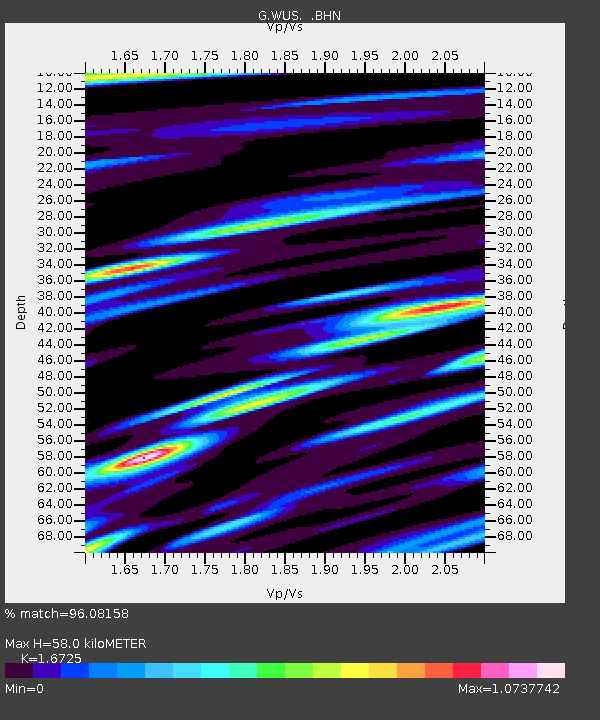
| Estimated Moho Depth: |
58.0 km |
| Estimated Crust Vp/Vs: |
1.67 |
| Assumed Crust Vp: |
6.353 km/s |
| Estimated Crust Vs: |
3.799 km/s |
| Estimated Crust Poisson's Ratio: |
0.22 |
|
| Radial Match: |
96.08158 % |
| Radial Bump: |
400 |
| Transverse Match: |
92.333435 % |
| Transverse Bump: |
400 |
| SOD ConfigId: |
4480 |
| Insert Time: |
2010-02-27 00:45:04.176 +0000 |
| GWidth: |
2.5 |
| Max Bumps: |
400 |
| Tol: |
0.001 |
|
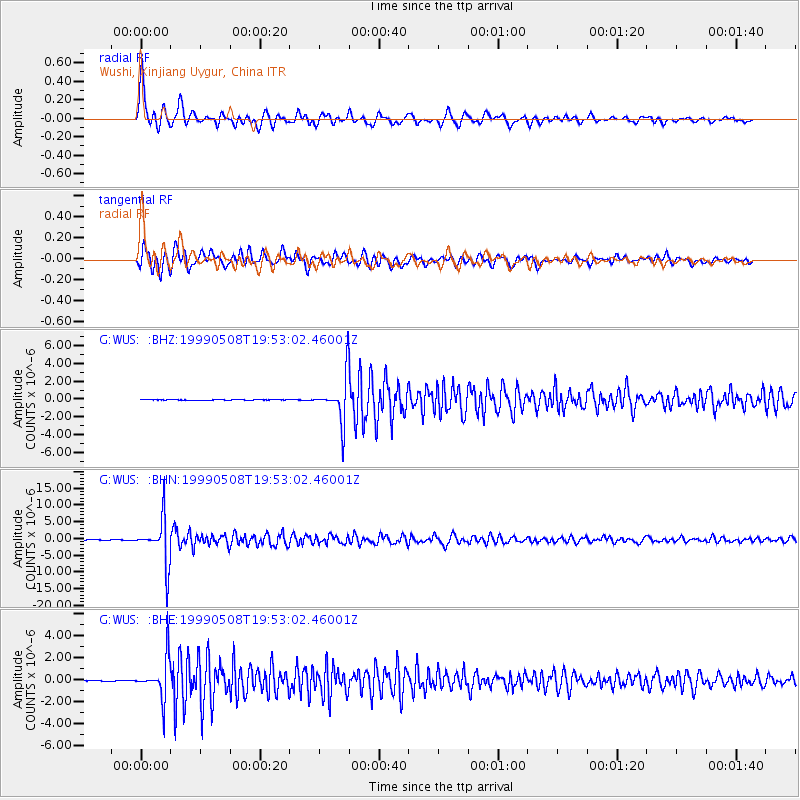
Signal To Noise
| Channel | StoN | STA | LTA |
| G:WUS: :BHN:19990508T19:53:02.46001Z | 181.34279 | 6.9470984E-6 | 3.8309206E-8 |
| G:WUS: :BHE:19990508T19:53:02.46001Z | 44.323505 | 1.8308167E-6 | 4.1305775E-8 |
| G:WUS: :BHZ:19990508T19:53:02.46001Z | 109.58042 | 2.5012519E-6 | 2.282572E-8 |
| Arrivals |
| Ps | 6.5 SECOND |
| PpPs | 23 SECOND |
| PsPs/PpSs | 30 SECOND |


