You are here: Home > Network List > G - GEOSCOPE Stations List
> Station WUS Wushi, Xinjiang Uygur, China > Earthquake Result Viewer
WUS Wushi, Xinjiang Uygur, China - Earthquake Result Viewer
| Earthquake location: |
New Britain Region, P.N.G. |
| Earthquake latitude/longitude: |
-5.2/150.9 |
| Earthquake time(UTC): |
1999/05/10 (130) 20:33:02 GMT |
| Earthquake Depth: |
138 km |
| Earthquake Magnitude: |
6.5 MB, 6.8 MS, 7.1 MW, 6.5 MB |
| Earthquake Catalog/Contributor: |
WHDF/NEIC |
|
| Network: |
G GEOSCOPE |
| Station: |
WUS Wushi, Xinjiang Uygur, China |
| Lat/Lon: |
41.20 N/79.22 E |
| Elevation: |
1457 m |
|
| Distance: |
79.8 deg |
| Az: |
313.29 deg |
| Baz: |
106.108 deg |
| Ray Param: |
0.04841827 |
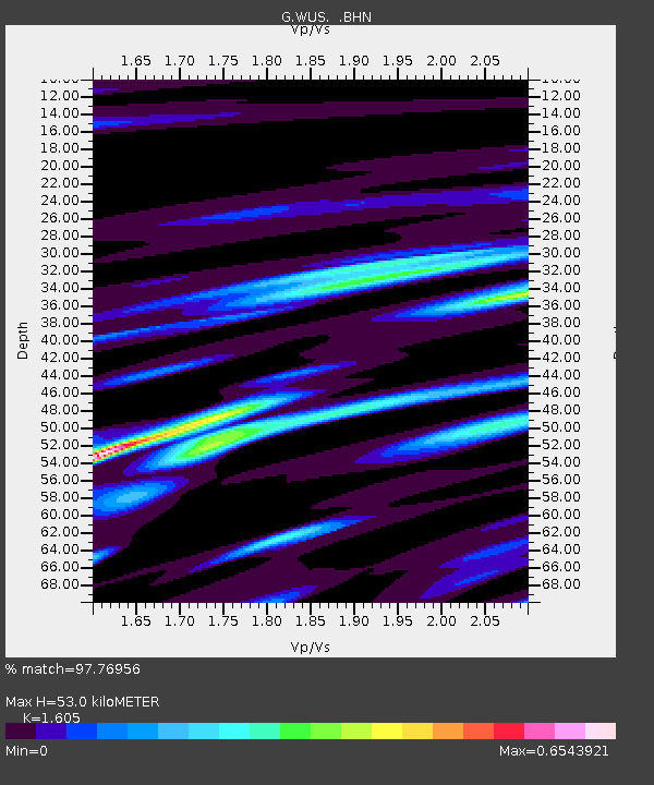
| Estimated Moho Depth: |
53.0 km |
| Estimated Crust Vp/Vs: |
1.61 |
| Assumed Crust Vp: |
6.353 km/s |
| Estimated Crust Vs: |
3.958 km/s |
| Estimated Crust Poisson's Ratio: |
0.18 |
|
| Radial Match: |
97.76956 % |
| Radial Bump: |
375 |
| Transverse Match: |
90.911354 % |
| Transverse Bump: |
400 |
| SOD ConfigId: |
4480 |
| Insert Time: |
2010-02-27 00:45:10.422 +0000 |
| GWidth: |
2.5 |
| Max Bumps: |
400 |
| Tol: |
0.001 |
|

Signal To Noise
| Channel | StoN | STA | LTA |
| G:WUS: :BHN:19990510T20:44:23.766025Z | 4.765619 | 6.6694264E-7 | 1.399488E-7 |
| G:WUS: :BHE:19990510T20:44:23.766025Z | 1.7087823 | 1.3128181E-7 | 7.68277E-8 |
| G:WUS: :BHZ:19990510T20:44:23.766025Z | 3.1281326 | 1.9804035E-7 | 6.330944E-8 |
| Arrivals |
| Ps | 5.2 SECOND |
| PpPs | 21 SECOND |
| PsPs/PpSs | 26 SECOND |


