You are here: Home > Network List > G - GEOSCOPE Stations List
> Station WUS Wushi, Xinjiang Uygur, China > Earthquake Result Viewer
WUS Wushi, Xinjiang Uygur, China - Earthquake Result Viewer
| Earthquake location: |
Hokkaido, Japan Region |
| Earthquake latitude/longitude: |
43.0/143.8 |
| Earthquake time(UTC): |
1999/05/12 (132) 17:59:22 GMT |
| Earthquake Depth: |
103 km |
| Earthquake Magnitude: |
5.9 MB, 6.2 MW, 6.1 MW |
| Earthquake Catalog/Contributor: |
WHDF/NEIC |
|
| Network: |
G GEOSCOPE |
| Station: |
WUS Wushi, Xinjiang Uygur, China |
| Lat/Lon: |
41.20 N/79.22 E |
| Elevation: |
1457 m |
|
| Distance: |
46.9 deg |
| Az: |
290.962 deg |
| Baz: |
65.146 deg |
| Ray Param: |
0.069995545 |
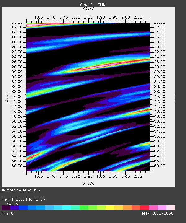
| Estimated Moho Depth: |
11.0 km |
| Estimated Crust Vp/Vs: |
1.60 |
| Assumed Crust Vp: |
6.353 km/s |
| Estimated Crust Vs: |
3.971 km/s |
| Estimated Crust Poisson's Ratio: |
0.18 |
|
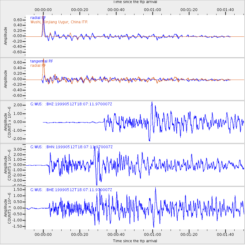
| Radial Match: |
94.49356 % |
| Radial Bump: |
400 |
| Transverse Match: |
86.948944 % |
| Transverse Bump: |
400 |
| SOD ConfigId: |
4480 |
| Insert Time: |
2010-02-27 00:45:12.580 +0000 |
| GWidth: |
2.5 |
| Max Bumps: |
400 |
| Tol: |
0.001 |
|
Signal To Noise
| Channel | StoN | STA | LTA |
| G:WUS: :BHN:19990512T18:07:11.970007Z | 15.058705 | 7.0214844E-7 | 4.662741E-8 |
| G:WUS: :BHE:19990512T18:07:11.970007Z | 3.67116 | 1.764773E-7 | 4.807126E-8 |
| G:WUS: :BHZ:19990512T18:07:11.970007Z | 15.229223 | 2.946243E-7 | 1.9345983E-8 |
| Arrivals |
| Ps | 1.1 SECOND |
| PpPs | 4.2 SECOND |
| PsPs/PpSs | 5.3 SECOND |


