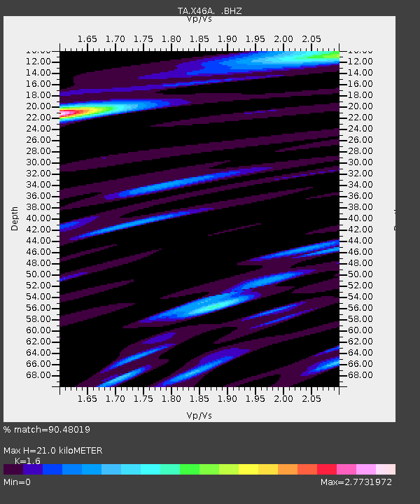
X46A Booneville, MS, USA - Earthquake Result Viewer
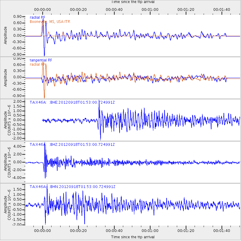
Earthquake location: Kodiak Island Region, Alaska
Earthquake latitude/longitude: 56.9/-154.1
Earthquake time(UTC): 2012/09/18 (262) 01:44:50 GMT
Earthquake Depth: 39 km
Earthquake Magnitude: 5.5 MB, 4.7 MS, 5.2 MW, 5.1 MW
Earthquake Catalog/Contributor: WHDF/NEIC
Network: TA USArray Transportable Network (new EarthScope stations)
Station: X46A Booneville, MS, USA
Lat/Lon: 34.56 N/88.58 W
Elevation: 150 m
Distance: 48.7 deg
Az: 88.181 deg
Baz: 318.41 deg
Ray Param: 0.06907183
Estimated Moho Depth: 21.0 km
Estimated Crust Vp/Vs: 1.60
Assumed Crust Vp: 6.38 km/s
Estimated Crust Vs: 3.988 km/s
Estimated Crust Poisson's Ratio: 0.18
Radial Match: 90.48019 %
Radial Bump: 400
Transverse Match: 76.077614 %
Transverse Bump: 400
SOD ConfigId: 476835
Insert Time: 2013-02-22 19:34:43.547 +0000
GWidth: 2.5
Max Bumps: 400
Tol: 0.001

Signal To Noise

ChannelStoNSTALTA
TA:X46A: :BHZ:20120918T01:53:00.724991Z17.7758431.5399121E-68.662948E-8
TA:X46A: :BHN:20120918T01:53:00.724991Z6.91013346.9602527E-71.007253E-7
TA:X46A: :BHE:20120918T01:53:00.724991Z7.31787067.670878E-71.0482391E-7
Arrivals
Ps2.1 SECOND
PpPs8.0 SECOND
PsPs/PpSs10 SECOND