You are here: Home > Network List > TA - USArray Transportable Network (new EarthScope stations) Stations List
> Station V46A Holladay, TN, USA > Earthquake Result Viewer
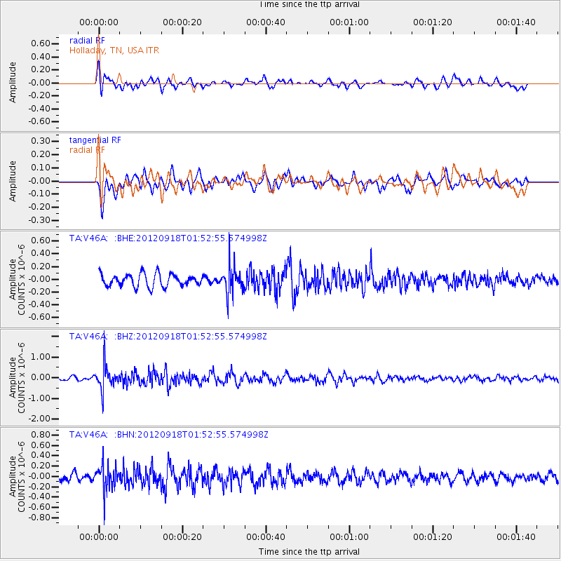
V46A Holladay, TN, USA - Earthquake Result Viewer
*The percent match for this event was below the threshold and hence no stack was calculated.
| Earthquake location: |
Kodiak Island Region, Alaska |
| Earthquake latitude/longitude: |
56.9/-154.1 |
| Earthquake time(UTC): |
2012/09/18 (262) 01:44:50 GMT |
| Earthquake Depth: |
39 km |
| Earthquake Magnitude: |
5.5 MB, 4.7 MS, 5.2 MW, 5.1 MW |
| Earthquake Catalog/Contributor: |
WHDF/NEIC |
|
| Network: |
TA USArray Transportable Network (new EarthScope stations) |
| Station: |
V46A Holladay, TN, USA |
| Lat/Lon: |
35.80 N/88.12 W |
| Elevation: |
162 m |
|
| Distance: |
48.1 deg |
| Az: |
86.691 deg |
| Baz: |
317.689 deg |
| Ray Param: |
$rayparam |
*The percent match for this event was below the threshold and hence was not used in the summary stack. |
|
| Radial Match: |
53.975567 % |
| Radial Bump: |
400 |
| Transverse Match: |
64.207214 % |
| Transverse Bump: |
400 |
| SOD ConfigId: |
476835 |
| Insert Time: |
2013-02-22 19:35:58.716 +0000 |
| GWidth: |
2.5 |
| Max Bumps: |
400 |
| Tol: |
0.001 |
|
Signal To Noise
| Channel | StoN | STA | LTA |
| TA:V46A: :BHZ:20120918T01:52:55.574998Z | 5.8175945 | 5.6437574E-7 | 9.701188E-8 |
| TA:V46A: :BHN:20120918T01:52:55.574998Z | 3.619168 | 2.3746188E-7 | 6.5612284E-8 |
| TA:V46A: :BHE:20120918T01:52:55.574998Z | 2.1772914 | 2.14399E-7 | 9.847051E-8 |
| Arrivals |
| Ps | |
| PpPs | |
| PsPs/PpSs | |


