You are here: Home > Network List > TA - USArray Transportable Network (new EarthScope stations) Stations List
> Station Y51A Rockmart, GA, USA > Earthquake Result Viewer
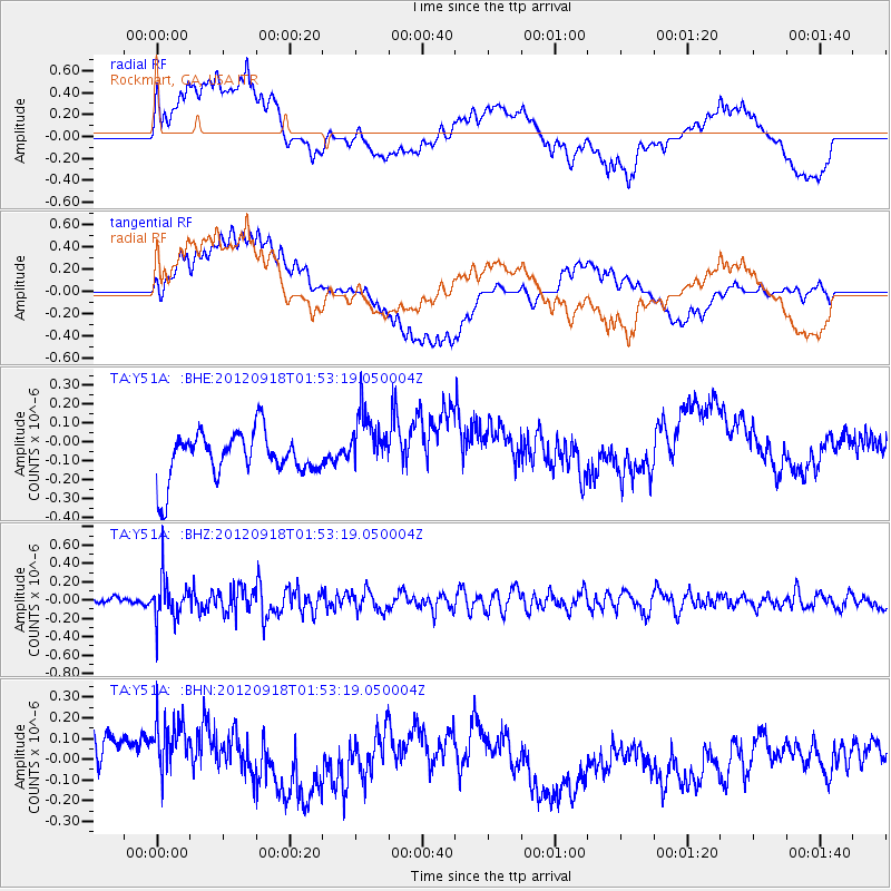
Y51A Rockmart, GA, USA - Earthquake Result Viewer
*The percent match for this event was below the threshold and hence no stack was calculated.
| Earthquake location: |
Kodiak Island Region, Alaska |
| Earthquake latitude/longitude: |
56.9/-154.1 |
| Earthquake time(UTC): |
2012/09/18 (262) 01:44:50 GMT |
| Earthquake Depth: |
39 km |
| Earthquake Magnitude: |
5.5 MB, 4.7 MS, 5.2 MW, 5.1 MW |
| Earthquake Catalog/Contributor: |
WHDF/NEIC |
|
| Network: |
TA USArray Transportable Network (new EarthScope stations) |
| Station: |
Y51A Rockmart, GA, USA |
| Lat/Lon: |
33.90 N/85.06 W |
| Elevation: |
380 m |
|
| Distance: |
51.2 deg |
| Az: |
85.886 deg |
| Baz: |
318.904 deg |
| Ray Param: |
$rayparam |
*The percent match for this event was below the threshold and hence was not used in the summary stack. |
|
| Radial Match: |
56.826637 % |
| Radial Bump: |
400 |
| Transverse Match: |
49.68496 % |
| Transverse Bump: |
400 |
| SOD ConfigId: |
476835 |
| Insert Time: |
2013-02-22 19:38:00.122 +0000 |
| GWidth: |
2.5 |
| Max Bumps: |
400 |
| Tol: |
0.001 |
|
Signal To Noise
| Channel | StoN | STA | LTA |
| TA:Y51A: :BHZ:20120918T01:53:19.050004Z | 3.92723 | 2.2995916E-7 | 5.8555056E-8 |
| TA:Y51A: :BHN:20120918T01:53:19.050004Z | 1.6004089 | 2.3571573E-7 | 1.472847E-7 |
| TA:Y51A: :BHE:20120918T01:53:19.050004Z | 1.3236232 | 1.5823427E-7 | 1.1954631E-7 |
| Arrivals |
| Ps | |
| PpPs | |
| PsPs/PpSs | |


