You are here: Home > Network List > TA - USArray Transportable Network (new EarthScope stations) Stations List
> Station N49A Columbus Grove, OH, USA > Earthquake Result Viewer
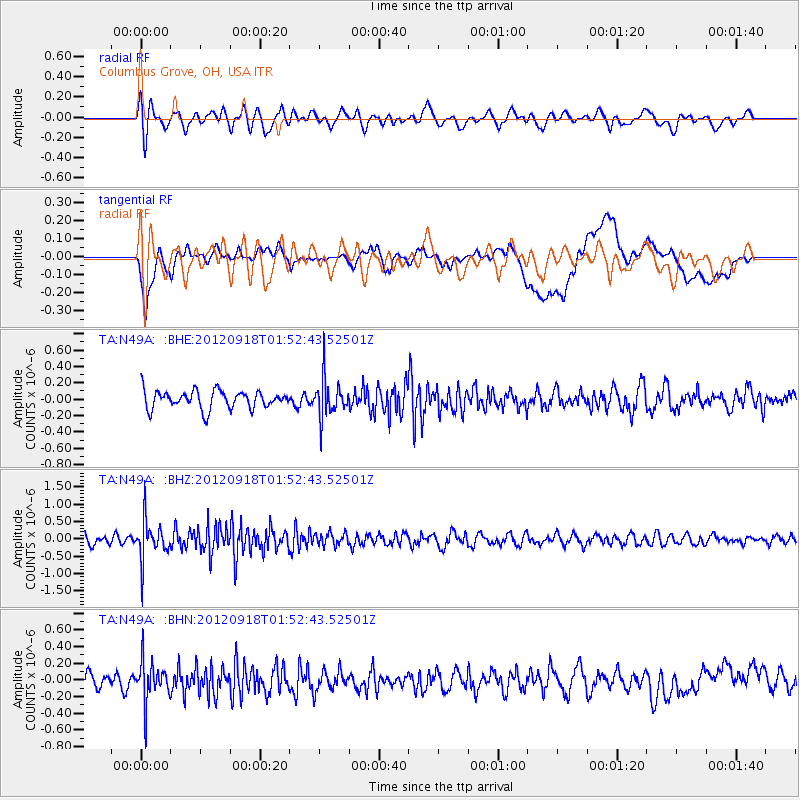
N49A Columbus Grove, OH, USA - Earthquake Result Viewer
*The percent match for this event was below the threshold and hence no stack was calculated.
| Earthquake location: |
Kodiak Island Region, Alaska |
| Earthquake latitude/longitude: |
56.9/-154.1 |
| Earthquake time(UTC): |
2012/09/18 (262) 01:44:50 GMT |
| Earthquake Depth: |
39 km |
| Earthquake Magnitude: |
5.5 MB, 4.7 MS, 5.2 MW, 5.1 MW |
| Earthquake Catalog/Contributor: |
WHDF/NEIC |
|
| Network: |
TA USArray Transportable Network (new EarthScope stations) |
| Station: |
N49A Columbus Grove, OH, USA |
| Lat/Lon: |
40.92 N/84.18 W |
| Elevation: |
225 m |
|
| Distance: |
46.5 deg |
| Az: |
78.837 deg |
| Baz: |
314.792 deg |
| Ray Param: |
$rayparam |
*The percent match for this event was below the threshold and hence was not used in the summary stack. |
|
| Radial Match: |
68.21868 % |
| Radial Bump: |
400 |
| Transverse Match: |
56.630394 % |
| Transverse Bump: |
400 |
| SOD ConfigId: |
476835 |
| Insert Time: |
2013-02-22 19:42:07.277 +0000 |
| GWidth: |
2.5 |
| Max Bumps: |
400 |
| Tol: |
0.001 |
|
Signal To Noise
| Channel | StoN | STA | LTA |
| TA:N49A: :BHZ:20120918T01:52:43.52501Z | 2.8435519 | 5.4879985E-7 | 1.92998E-7 |
| TA:N49A: :BHN:20120918T01:52:43.52501Z | 2.1953728 | 2.4244056E-7 | 1.10432524E-7 |
| TA:N49A: :BHE:20120918T01:52:43.52501Z | 2.0769744 | 2.2924152E-7 | 1.1037282E-7 |
| Arrivals |
| Ps | |
| PpPs | |
| PsPs/PpSs | |


