You are here: Home > Network List > AZ - ANZA Regional Network Stations List
> Station LVA2 AZ.LVA2 > Earthquake Result Viewer
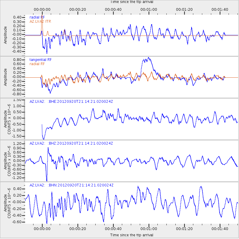
LVA2 AZ.LVA2 - Earthquake Result Viewer
*The percent match for this event was below the threshold and hence no stack was calculated.
| Earthquake location: |
Fiji Islands Region |
| Earthquake latitude/longitude: |
-20.8/-178.5 |
| Earthquake time(UTC): |
2012/09/20 (264) 21:03:42 GMT |
| Earthquake Depth: |
570 km |
| Earthquake Magnitude: |
5.7 MW, 5.3 MB, 5.7 MW |
| Earthquake Catalog/Contributor: |
WHDF/NEIC |
|
| Network: |
AZ ANZA Regional Network |
| Station: |
LVA2 AZ.LVA2 |
| Lat/Lon: |
33.35 N/116.56 W |
| Elevation: |
1435 m |
|
| Distance: |
79.9 deg |
| Az: |
48.621 deg |
| Baz: |
237.033 deg |
| Ray Param: |
$rayparam |
*The percent match for this event was below the threshold and hence was not used in the summary stack. |
|
| Radial Match: |
58.445385 % |
| Radial Bump: |
400 |
| Transverse Match: |
29.946556 % |
| Transverse Bump: |
400 |
| SOD ConfigId: |
476835 |
| Insert Time: |
2013-02-22 19:49:05.927 +0000 |
| GWidth: |
2.5 |
| Max Bumps: |
400 |
| Tol: |
0.001 |
|
Signal To Noise
| Channel | StoN | STA | LTA |
| AZ:LVA2: :BHZ:20120920T21:14:21.020024Z | 3.698189 | 5.6028796E-7 | 1.5150333E-7 |
| AZ:LVA2: :BHN:20120920T21:14:21.020024Z | 1.3401773 | 6.3259625E-7 | 4.720243E-7 |
| AZ:LVA2: :BHE:20120920T21:14:21.020024Z | 1.365879 | 6.273515E-7 | 4.5930233E-7 |
| Arrivals |
| Ps | |
| PpPs | |
| PsPs/PpSs | |


