You are here: Home > Network List > CB - China National Seismic Network Stations List
> Station CN2 Changchun,Jilin Province > Earthquake Result Viewer
CN2 Changchun,Jilin Province - Earthquake Result Viewer
| Earthquake location: |
South Indian Ocean |
| Earthquake latitude/longitude: |
-10.1/91.1 |
| Earthquake time(UTC): |
2014/06/14 (165) 11:11:00 GMT |
| Earthquake Depth: |
7.1 km |
| Earthquake Magnitude: |
6.4 MWP, 6.4 MWB |
| Earthquake Catalog/Contributor: |
NEIC PDE/NEIC COMCAT |
|
| Network: |
CB China National Seismic Network |
| Station: |
CN2 Changchun,Jilin Province |
| Lat/Lon: |
43.48 N/125.26 E |
| Elevation: |
223 m |
|
| Distance: |
61.7 deg |
| Az: |
27.69 deg |
| Baz: |
218.955 deg |
| Ray Param: |
0.06070714 |
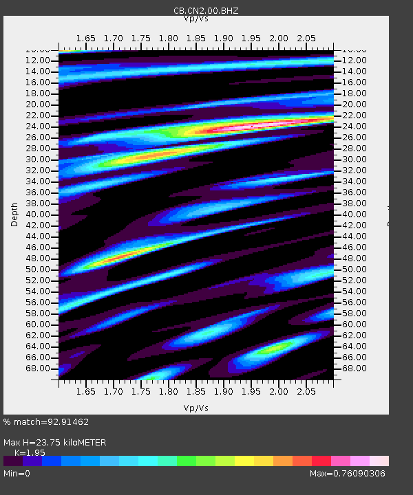
| Estimated Moho Depth: |
23.75 km |
| Estimated Crust Vp/Vs: |
1.95 |
| Assumed Crust Vp: |
6.459 km/s |
| Estimated Crust Vs: |
3.313 km/s |
| Estimated Crust Poisson's Ratio: |
0.32 |
|
| Radial Match: |
92.91462 % |
| Radial Bump: |
398 |
| Transverse Match: |
89.68047 % |
| Transverse Bump: |
400 |
| SOD ConfigId: |
3390531 |
| Insert Time: |
2019-04-12 06:27:56.261 +0000 |
| GWidth: |
2.5 |
| Max Bumps: |
400 |
| Tol: |
0.001 |
|

Signal To Noise
| Channel | StoN | STA | LTA |
| CB:CN2:00:BHZ:20140614T11:20:48.91002Z | 5.7475314 | 5.6539767E-7 | 9.837227E-8 |
| CB:CN2:00:BHN:20140614T11:20:48.91002Z | 2.431154 | 1.929406E-7 | 7.936173E-8 |
| CB:CN2:00:BHE:20140614T11:20:48.91002Z | 1.8937504 | 1.9303948E-7 | 1.01935015E-7 |
| Arrivals |
| Ps | 3.6 SECOND |
| PpPs | 10 SECOND |
| PsPs/PpSs | 14 SECOND |


