You are here: Home > Network List > CI - Caltech Regional Seismic Network Stations List
> Station MPM Manuel Prospect Mine, California, USA > Earthquake Result Viewer
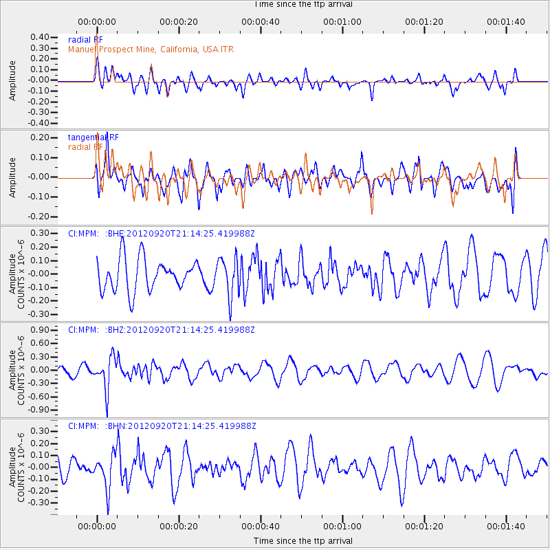
MPM Manuel Prospect Mine, California, USA - Earthquake Result Viewer
*The percent match for this event was below the threshold and hence no stack was calculated.
| Earthquake location: |
Fiji Islands Region |
| Earthquake latitude/longitude: |
-20.8/-178.5 |
| Earthquake time(UTC): |
2012/09/20 (264) 21:03:42 GMT |
| Earthquake Depth: |
570 km |
| Earthquake Magnitude: |
5.7 MW, 5.3 MB, 5.7 MW |
| Earthquake Catalog/Contributor: |
WHDF/NEIC |
|
| Network: |
CI Caltech Regional Seismic Network |
| Station: |
MPM Manuel Prospect Mine, California, USA |
| Lat/Lon: |
36.06 N/117.49 W |
| Elevation: |
185 m |
|
| Distance: |
80.7 deg |
| Az: |
45.908 deg |
| Baz: |
236.051 deg |
| Ray Param: |
$rayparam |
*The percent match for this event was below the threshold and hence was not used in the summary stack. |
|
| Radial Match: |
45.65766 % |
| Radial Bump: |
400 |
| Transverse Match: |
42.744953 % |
| Transverse Bump: |
400 |
| SOD ConfigId: |
476835 |
| Insert Time: |
2013-02-22 19:51:50.859 +0000 |
| GWidth: |
2.5 |
| Max Bumps: |
400 |
| Tol: |
0.001 |
|
Signal To Noise
| Channel | StoN | STA | LTA |
| CI:MPM: :BHZ:20120920T21:14:25.419988Z | 2.7655587 | 3.6335803E-7 | 1.3138684E-7 |
| CI:MPM: :BHN:20120920T21:14:25.419988Z | 1.1574981 | 1.4436273E-7 | 1.2471962E-7 |
| CI:MPM: :BHE:20120920T21:14:25.419988Z | 1.2084721 | 1.432135E-7 | 1.18507906E-7 |
| Arrivals |
| Ps | |
| PpPs | |
| PsPs/PpSs | |


