You are here: Home > Network List > CI - Caltech Regional Seismic Network Stations List
> Station DAN Danby, California, USA > Earthquake Result Viewer
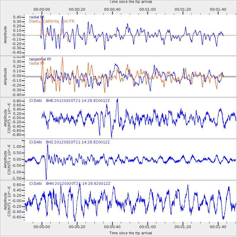
DAN Danby, California, USA - Earthquake Result Viewer
*The percent match for this event was below the threshold and hence no stack was calculated.
| Earthquake location: |
Fiji Islands Region |
| Earthquake latitude/longitude: |
-20.8/-178.5 |
| Earthquake time(UTC): |
2012/09/20 (264) 21:03:42 GMT |
| Earthquake Depth: |
570 km |
| Earthquake Magnitude: |
5.7 MW, 5.3 MB, 5.7 MW |
| Earthquake Catalog/Contributor: |
WHDF/NEIC |
|
| Network: |
CI Caltech Regional Seismic Network |
| Station: |
DAN Danby, California, USA |
| Lat/Lon: |
34.64 N/115.38 W |
| Elevation: |
398 m |
|
| Distance: |
81.4 deg |
| Az: |
48.064 deg |
| Baz: |
237.6 deg |
| Ray Param: |
$rayparam |
*The percent match for this event was below the threshold and hence was not used in the summary stack. |
|
| Radial Match: |
63.962547 % |
| Radial Bump: |
400 |
| Transverse Match: |
49.46952 % |
| Transverse Bump: |
400 |
| SOD ConfigId: |
476835 |
| Insert Time: |
2013-02-22 19:52:03.506 +0000 |
| GWidth: |
2.5 |
| Max Bumps: |
400 |
| Tol: |
0.001 |
|
Signal To Noise
| Channel | StoN | STA | LTA |
| CI:DAN: :BHZ:20120920T21:14:28.820012Z | 5.2922087 | 5.6959266E-7 | 1.0762854E-7 |
| CI:DAN: :BHN:20120920T21:14:28.820012Z | 1.7103978 | 2.6750814E-7 | 1.5640113E-7 |
| CI:DAN: :BHE:20120920T21:14:28.820012Z | 1.7807577 | 2.9576407E-7 | 1.6608888E-7 |
| Arrivals |
| Ps | |
| PpPs | |
| PsPs/PpSs | |


