You are here: Home > Network List > GT - Global Telemetered Seismograph Network (USAF/USGS) Stations List
> Station PLCA Paso Flores, Argentina > Earthquake Result Viewer
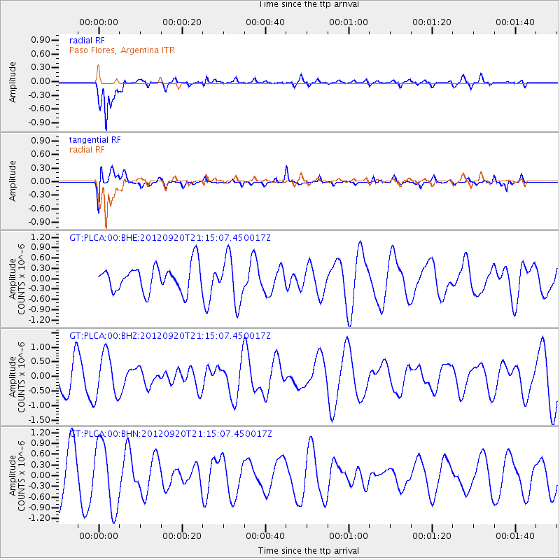
PLCA Paso Flores, Argentina - Earthquake Result Viewer
*The percent match for this event was below the threshold and hence no stack was calculated.
| Earthquake location: |
Fiji Islands Region |
| Earthquake latitude/longitude: |
-20.8/-178.5 |
| Earthquake time(UTC): |
2012/09/20 (264) 21:03:42 GMT |
| Earthquake Depth: |
570 km |
| Earthquake Magnitude: |
5.7 MW, 5.3 MB, 5.7 MW |
| Earthquake Catalog/Contributor: |
WHDF/NEIC |
|
| Network: |
GT Global Telemetered Seismograph Network (USAF/USGS) |
| Station: |
PLCA Paso Flores, Argentina |
| Lat/Lon: |
40.73 S/70.55 W |
| Elevation: |
1050 m |
|
| Distance: |
89.4 deg |
| Az: |
133.704 deg |
| Baz: |
242.911 deg |
| Ray Param: |
$rayparam |
*The percent match for this event was below the threshold and hence was not used in the summary stack. |
|
| Radial Match: |
80.536545 % |
| Radial Bump: |
400 |
| Transverse Match: |
58.389317 % |
| Transverse Bump: |
400 |
| SOD ConfigId: |
476835 |
| Insert Time: |
2013-02-22 19:54:30.101 +0000 |
| GWidth: |
2.5 |
| Max Bumps: |
400 |
| Tol: |
0.001 |
|
Signal To Noise
| Channel | StoN | STA | LTA |
| GT:PLCA:00:BHZ:20120920T21:15:07.450017Z | 1.790872 | 7.4032886E-7 | 4.1339015E-7 |
| GT:PLCA:00:BHN:20120920T21:15:07.450017Z | 1.7731452 | 9.4872416E-7 | 5.350516E-7 |
| GT:PLCA:00:BHE:20120920T21:15:07.450017Z | 1.8002048 | 6.732262E-7 | 3.7397203E-7 |
| Arrivals |
| Ps | |
| PpPs | |
| PsPs/PpSs | |


