You are here: Home > Network List > TA - USArray Transportable Network (new EarthScope stations) Stations List
> Station J05D Fort Rock, OR, USA > Earthquake Result Viewer
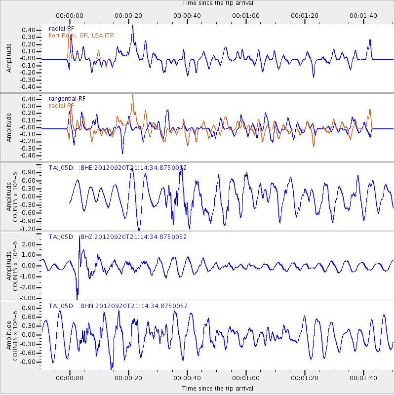
J05D Fort Rock, OR, USA - Earthquake Result Viewer
*The percent match for this event was below the threshold and hence no stack was calculated.
| Earthquake location: |
Fiji Islands Region |
| Earthquake latitude/longitude: |
-20.8/-178.5 |
| Earthquake time(UTC): |
2012/09/20 (264) 21:03:42 GMT |
| Earthquake Depth: |
570 km |
| Earthquake Magnitude: |
5.7 MW, 5.3 MB, 5.7 MW |
| Earthquake Catalog/Contributor: |
WHDF/NEIC |
|
| Network: |
TA USArray Transportable Network (new EarthScope stations) |
| Station: |
J05D Fort Rock, OR, USA |
| Lat/Lon: |
43.28 N/121.23 W |
| Elevation: |
1541 m |
|
| Distance: |
82.6 deg |
| Az: |
38.281 deg |
| Baz: |
232.558 deg |
| Ray Param: |
$rayparam |
*The percent match for this event was below the threshold and hence was not used in the summary stack. |
|
| Radial Match: |
56.02283 % |
| Radial Bump: |
400 |
| Transverse Match: |
69.08662 % |
| Transverse Bump: |
400 |
| SOD ConfigId: |
476835 |
| Insert Time: |
2013-02-22 19:57:29.901 +0000 |
| GWidth: |
2.5 |
| Max Bumps: |
400 |
| Tol: |
0.001 |
|
Signal To Noise
| Channel | StoN | STA | LTA |
| TA:J05D: :BHZ:20120920T21:14:34.875005Z | 3.2398205 | 1.2236453E-6 | 3.7768922E-7 |
| TA:J05D: :BHN:20120920T21:14:34.875005Z | 1.0827438 | 3.9075692E-7 | 3.6089511E-7 |
| TA:J05D: :BHE:20120920T21:14:34.875005Z | 0.6070378 | 2.874158E-7 | 4.7347265E-7 |
| Arrivals |
| Ps | |
| PpPs | |
| PsPs/PpSs | |


