You are here: Home > Network List > TA - USArray Transportable Network (new EarthScope stations) Stations List
> Station L04D Klamath Falls, OR, USA > Earthquake Result Viewer
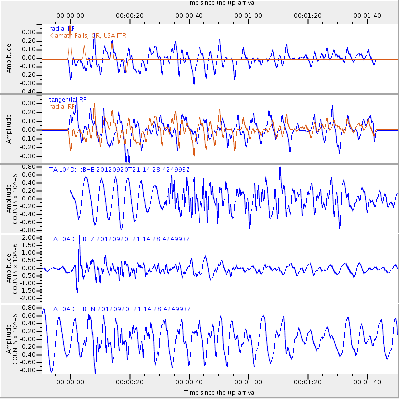
L04D Klamath Falls, OR, USA - Earthquake Result Viewer
*The percent match for this event was below the threshold and hence no stack was calculated.
| Earthquake location: |
Fiji Islands Region |
| Earthquake latitude/longitude: |
-20.8/-178.5 |
| Earthquake time(UTC): |
2012/09/20 (264) 21:03:42 GMT |
| Earthquake Depth: |
570 km |
| Earthquake Magnitude: |
5.7 MW, 5.3 MB, 5.7 MW |
| Earthquake Catalog/Contributor: |
WHDF/NEIC |
|
| Network: |
TA USArray Transportable Network (new EarthScope stations) |
| Station: |
L04D Klamath Falls, OR, USA |
| Lat/Lon: |
42.22 N/122.30 W |
| Elevation: |
1437 m |
|
| Distance: |
81.3 deg |
| Az: |
38.644 deg |
| Baz: |
231.885 deg |
| Ray Param: |
$rayparam |
*The percent match for this event was below the threshold and hence was not used in the summary stack. |
|
| Radial Match: |
54.673782 % |
| Radial Bump: |
400 |
| Transverse Match: |
74.566444 % |
| Transverse Bump: |
400 |
| SOD ConfigId: |
476835 |
| Insert Time: |
2013-02-22 19:58:05.687 +0000 |
| GWidth: |
2.5 |
| Max Bumps: |
400 |
| Tol: |
0.001 |
|
Signal To Noise
| Channel | StoN | STA | LTA |
| TA:L04D: :BHZ:20120920T21:14:28.424993Z | 3.2523851 | 7.2533925E-7 | 2.2301764E-7 |
| TA:L04D: :BHN:20120920T21:14:28.424993Z | 0.879372 | 3.1921283E-7 | 3.630009E-7 |
| TA:L04D: :BHE:20120920T21:14:28.424993Z | 0.6025769 | 2.3372516E-7 | 3.8787604E-7 |
| Arrivals |
| Ps | |
| PpPs | |
| PsPs/PpSs | |


