You are here: Home > Network List > PF - Volcanologic Network of Piton de Fournaise-OVPF Stations List
> Station BON Bory Nord > Earthquake Result Viewer
BON Bory Nord - Earthquake Result Viewer
| Earthquake location: |
South Indian Ocean |
| Earthquake latitude/longitude: |
-10.1/91.1 |
| Earthquake time(UTC): |
2014/06/14 (165) 11:11:00 GMT |
| Earthquake Depth: |
7.1 km |
| Earthquake Magnitude: |
6.4 MWP, 6.4 MWB |
| Earthquake Catalog/Contributor: |
NEIC PDE/NEIC COMCAT |
|
| Network: |
PF Volcanologic Network of Piton de Fournaise-OVPF |
| Station: |
BON Bory Nord |
| Lat/Lon: |
21.24 S/55.71 E |
| Elevation: |
2552 m |
|
| Distance: |
35.7 deg |
| Az: |
247.578 deg |
| Baz: |
77.389 deg |
| Ray Param: |
0.07707793 |
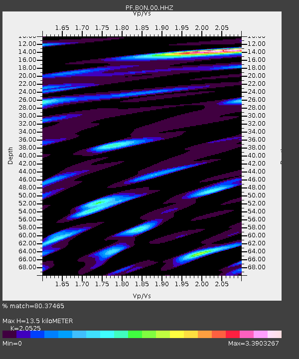
| Estimated Moho Depth: |
13.5 km |
| Estimated Crust Vp/Vs: |
2.05 |
| Assumed Crust Vp: |
4.73 km/s |
| Estimated Crust Vs: |
2.305 km/s |
| Estimated Crust Poisson's Ratio: |
0.34 |
|
| Radial Match: |
80.37465 % |
| Radial Bump: |
400 |
| Transverse Match: |
71.3749 % |
| Transverse Bump: |
400 |
| SOD ConfigId: |
3390531 |
| Insert Time: |
2019-04-12 06:29:04.732 +0000 |
| GWidth: |
2.5 |
| Max Bumps: |
400 |
| Tol: |
0.001 |
|
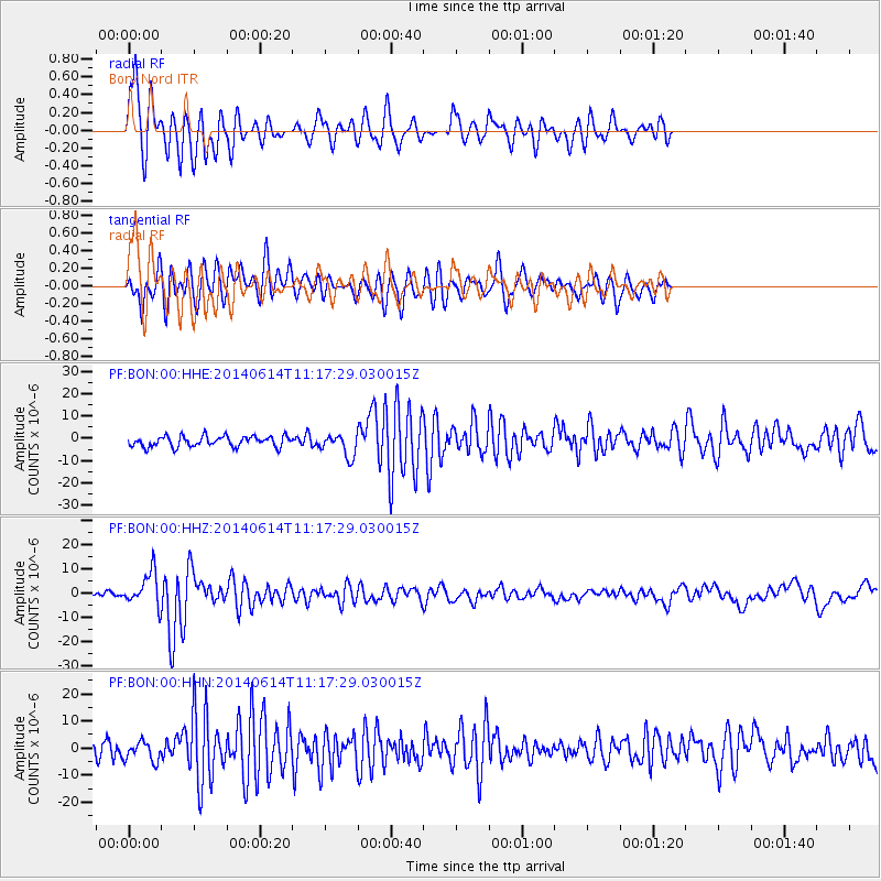
Signal To Noise
| Channel | StoN | STA | LTA |
| PF:BON:00:HHZ:20140614T11:17:29.030015Z | 6.937223 | 7.0362444E-6 | 1.014274E-6 |
| PF:BON:00:HHN:20140614T11:17:29.030015Z | 1.0192373 | 3.4944642E-6 | 3.4285088E-6 |
| PF:BON:00:HHE:20140614T11:17:29.030015Z | 2.1083112 | 4.989079E-6 | 2.3663865E-6 |
| Arrivals |
| Ps | 3.1 SECOND |
| PpPs | 8.4 SECOND |
| PsPs/PpSs | 12 SECOND |


