You are here: Home > Network List > TA - USArray Transportable Network (new EarthScope stations) Stations List
> Station K36A Gilmore City, IA, USA > Earthquake Result Viewer
K36A Gilmore City, IA, USA - Earthquake Result Viewer
*The percent match for this event was below the threshold and hence no stack was calculated.
| Earthquake location: |
Greece |
| Earthquake latitude/longitude: |
38.1/22.8 |
| Earthquake time(UTC): |
2012/09/22 (266) 03:52:26 GMT |
| Earthquake Depth: |
10 km |
| Earthquake Magnitude: |
5.6 MB, 5.0 MW, 5.1 ML |
| Earthquake Catalog/Contributor: |
WHDF/NEIC |
|
| Network: |
TA USArray Transportable Network (new EarthScope stations) |
| Station: |
K36A Gilmore City, IA, USA |
| Lat/Lon: |
42.64 N/94.45 W |
| Elevation: |
364 m |
|
| Distance: |
81.5 deg |
| Az: |
318.43 deg |
| Baz: |
45.188 deg |
| Ray Param: |
$rayparam |
*The percent match for this event was below the threshold and hence was not used in the summary stack. |
|
| Radial Match: |
66.52118 % |
| Radial Bump: |
400 |
| Transverse Match: |
54.526222 % |
| Transverse Bump: |
400 |
| SOD ConfigId: |
476835 |
| Insert Time: |
2013-02-22 20:14:21.578 +0000 |
| GWidth: |
2.5 |
| Max Bumps: |
400 |
| Tol: |
0.001 |
|
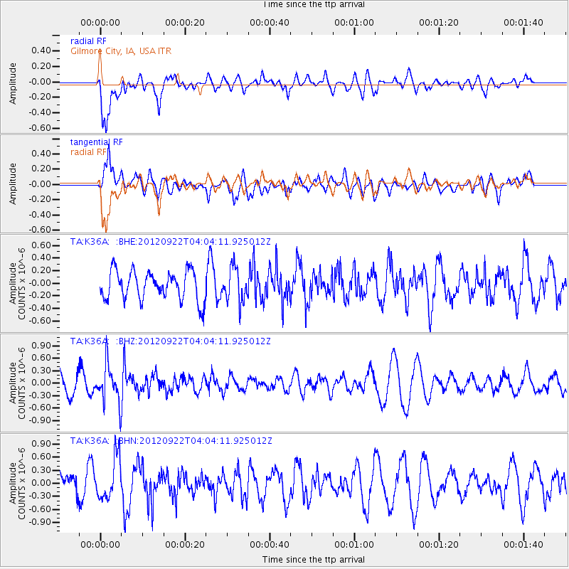
Signal To Noise
| Channel | StoN | STA | LTA |
| TA:K36A: :BHZ:20120922T04:04:11.925012Z | 2.1027262 | 4.5907672E-7 | 2.1832454E-7 |
| TA:K36A: :BHN:20120922T04:04:11.925012Z | 1.5413626 | 4.925588E-7 | 3.195606E-7 |
| TA:K36A: :BHE:20120922T04:04:11.925012Z | 1.191422 | 2.736496E-7 | 2.296832E-7 |
| Arrivals |
| Ps | |
| PpPs | |
| PsPs/PpSs | |


