You are here: Home > Network List > TA - USArray Transportable Network (new EarthScope stations) Stations List
> Station Z41A Richland Creek Farm, El Dorado, AR, USA > Earthquake Result Viewer
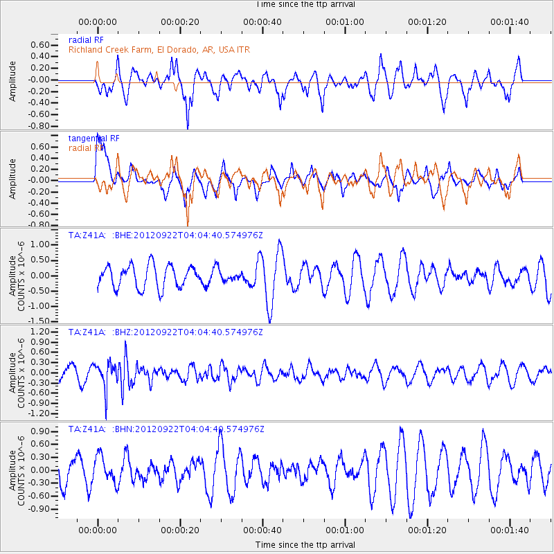
Z41A Richland Creek Farm, El Dorado, AR, USA - Earthquake Result Viewer
*The percent match for this event was below the threshold and hence no stack was calculated.
| Earthquake location: |
Greece |
| Earthquake latitude/longitude: |
38.1/22.8 |
| Earthquake time(UTC): |
2012/09/22 (266) 03:52:26 GMT |
| Earthquake Depth: |
10 km |
| Earthquake Magnitude: |
5.6 MB, 5.0 MW, 5.1 ML |
| Earthquake Catalog/Contributor: |
WHDF/NEIC |
|
| Network: |
TA USArray Transportable Network (new EarthScope stations) |
| Station: |
Z41A Richland Creek Farm, El Dorado, AR, USA |
| Lat/Lon: |
33.26 N/92.80 W |
| Elevation: |
62 m |
|
| Distance: |
87.1 deg |
| Az: |
310.821 deg |
| Baz: |
45.443 deg |
| Ray Param: |
$rayparam |
*The percent match for this event was below the threshold and hence was not used in the summary stack. |
|
| Radial Match: |
63.736233 % |
| Radial Bump: |
400 |
| Transverse Match: |
51.198727 % |
| Transverse Bump: |
400 |
| SOD ConfigId: |
476835 |
| Insert Time: |
2013-02-22 20:16:10.419 +0000 |
| GWidth: |
2.5 |
| Max Bumps: |
400 |
| Tol: |
0.001 |
|
Signal To Noise
| Channel | StoN | STA | LTA |
| TA:Z41A: :BHZ:20120922T04:04:40.574976Z | 2.6993363 | 3.7489505E-7 | 1.3888415E-7 |
| TA:Z41A: :BHN:20120922T04:04:40.574976Z | 1.0119663 | 3.1294124E-7 | 3.0924076E-7 |
| TA:Z41A: :BHE:20120922T04:04:40.574976Z | 0.42890134 | 1.559432E-7 | 3.6358756E-7 |
| Arrivals |
| Ps | |
| PpPs | |
| PsPs/PpSs | |


