You are here: Home > Network List > G - GEOSCOPE Stations List
> Station WUS Wushi, Xinjiang Uygur, China > Earthquake Result Viewer
WUS Wushi, Xinjiang Uygur, China - Earthquake Result Viewer

| Earthquake location: |
Solomon Islands |
| Earthquake latitude/longitude: |
-9.9/159.1 |
| Earthquake time(UTC): |
1991/02/09 (040) 16:18:58 GMT |
| Earthquake Depth: |
10 km |
| Earthquake Magnitude: |
6.3 MB, 6.9 MS, 6.8 UNKNOWN |
| Earthquake Catalog/Contributor: |
WHDF/NEIC |
|
| Network: |
G GEOSCOPE |
| Station: |
WUS Wushi, Xinjiang Uygur, China |
| Lat/Lon: |
41.20 N/79.22 E |
| Elevation: |
1457 m |
|
| Distance: |
88.9 deg |
| Az: |
312.013 deg |
| Baz: |
104.011 deg |
| Ray Param: |
0.042239435 |
| Estimated Moho Depth: |
34.5 km |
| Estimated Crust Vp/Vs: |
2.09 |
| Assumed Crust Vp: |
6.353 km/s |
| Estimated Crust Vs: |
3.047 km/s |
| Estimated Crust Poisson's Ratio: |
0.35 |
|
| Radial Match: |
95.07009 % |
| Radial Bump: |
259 |
| Transverse Match: |
92.37926 % |
| Transverse Bump: |
400 |
| SOD ConfigId: |
16938 |
| Insert Time: |
2010-02-27 00:46:43.330 +0000 |
| GWidth: |
2.5 |
| Max Bumps: |
400 |
| Tol: |
0.001 |
|
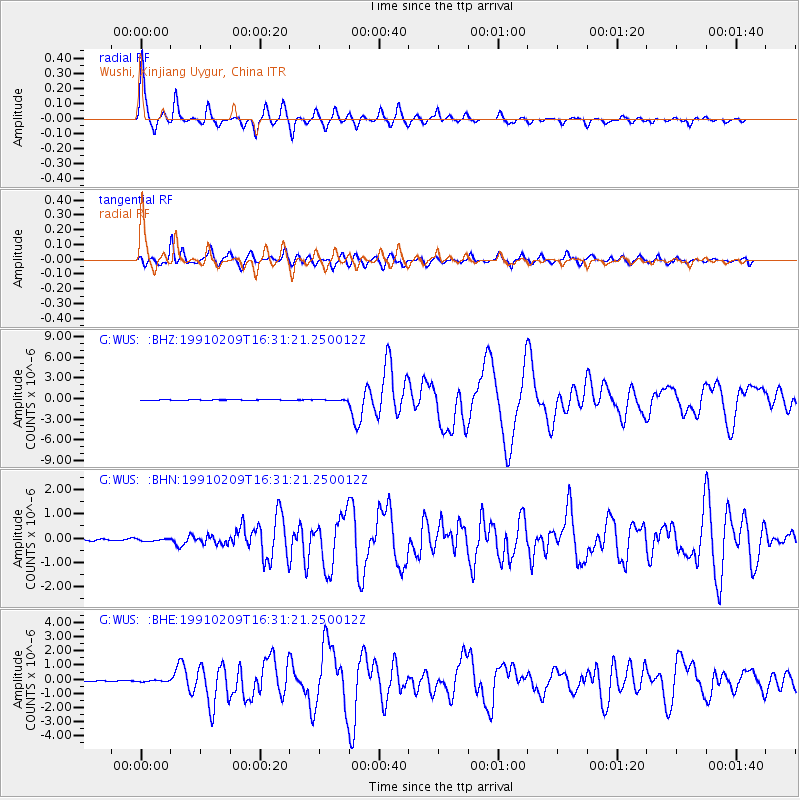
Signal To Noise
| Channel | StoN | STA | LTA |
| G:WUS: :BHN:19910209T16:31:21.250012Z | 1.1301454 | 4.480122E-8 | 3.9641996E-8 |
| G:WUS: :BHE:19910209T16:31:21.250012Z | 1.1369394 | 4.6403343E-8 | 4.0814264E-8 |
| G:WUS: :BHZ:19910209T16:31:21.250012Z | 1.1597198 | 6.639882E-8 | 5.7254187E-8 |
| Arrivals |
| Ps | 6.0 SECOND |
| PpPs | 16 SECOND |
| PsPs/PpSs | 22 SECOND |


