You are here: Home > Network List > YB13 - Continental Dynamics/Cent. Anatolian Tectonics:Surface to Mantle Dynamics During Stations List
> Station AT38 Bayraktepe?,Gaziantep,Turkey > Earthquake Result Viewer
AT38 Bayraktepe?,Gaziantep,Turkey - Earthquake Result Viewer
| Earthquake location: |
South Indian Ocean |
| Earthquake latitude/longitude: |
-10.1/91.1 |
| Earthquake time(UTC): |
2014/06/14 (165) 11:11:00 GMT |
| Earthquake Depth: |
7.1 km |
| Earthquake Magnitude: |
6.4 MWP, 6.4 MWB |
| Earthquake Catalog/Contributor: |
NEIC PDE/NEIC COMCAT |
|
| Network: |
YB Continental Dynamics/Cent. Anatolian Tectonics:Surface to Mantle Dynamics During |
| Station: |
AT38 Bayraktepe?,Gaziantep,Turkey |
| Lat/Lon: |
37.04 N/36.81 E |
| Elevation: |
692 m |
|
| Distance: |
69.1 deg |
| Az: |
315.969 deg |
| Baz: |
121.194 deg |
| Ray Param: |
0.05586297 |
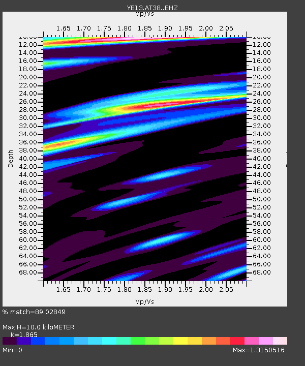
| Estimated Moho Depth: |
10.0 km |
| Estimated Crust Vp/Vs: |
1.87 |
| Assumed Crust Vp: |
6.247 km/s |
| Estimated Crust Vs: |
3.349 km/s |
| Estimated Crust Poisson's Ratio: |
0.30 |
|
| Radial Match: |
89.02849 % |
| Radial Bump: |
400 |
| Transverse Match: |
87.51041 % |
| Transverse Bump: |
400 |
| SOD ConfigId: |
3390531 |
| Insert Time: |
2019-04-12 06:30:23.289 +0000 |
| GWidth: |
2.5 |
| Max Bumps: |
400 |
| Tol: |
0.001 |
|

Signal To Noise
| Channel | StoN | STA | LTA |
| YB:AT38: :BHZ:20140614T11:21:36.540024Z | 12.141717 | 9.112575E-7 | 7.505178E-8 |
| YB:AT38: :BHN:20140614T11:21:36.540024Z | 4.410227 | 1.7567277E-7 | 3.9833044E-8 |
| YB:AT38: :BHE:20140614T11:21:36.540024Z | 5.037407 | 2.5151323E-7 | 4.9929103E-8 |
| Arrivals |
| Ps | 1.4 SECOND |
| PpPs | 4.4 SECOND |
| PsPs/PpSs | 5.9 SECOND |


