You are here: Home > Network List > G - GEOSCOPE Stations List
> Station WUS Wushi, Xinjiang Uygur, China > Earthquake Result Viewer
WUS Wushi, Xinjiang Uygur, China - Earthquake Result Viewer
| Earthquake location: |
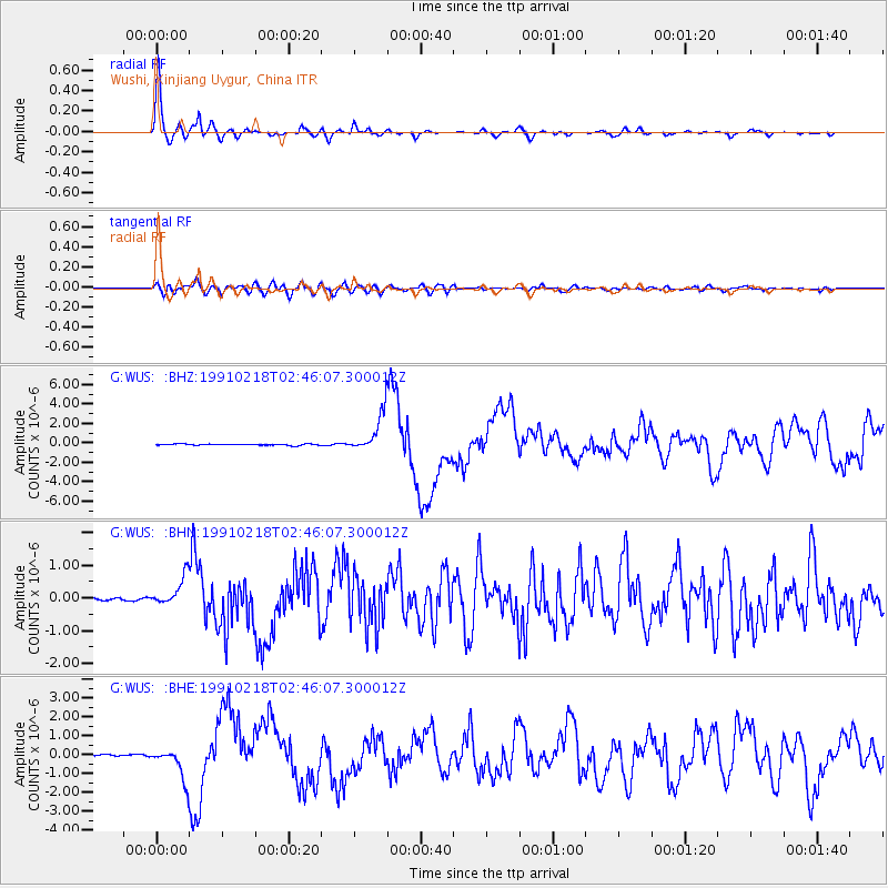
Mindanao, Philippines |
| Earthquake latitude/longitude: |
8.8/126.6 |
| Earthquake time(UTC): |
1991/02/18 (049) 02:37:28 GMT |
| Earthquake Depth: |
57 km |
| Earthquake Magnitude: |
5.9 MB, 6.6 MS, 6.6 UNKNOWN |
| Earthquake Catalog/Contributor: |
WHDF/NEIC |
|
| Network: |
G GEOSCOPE |
| Station: |
WUS Wushi, Xinjiang Uygur, China |
| Lat/Lon: |
41.20 N/79.22 E |
| Elevation: |
1457 m |
|
| Distance: |
52.8 deg |
| Az: |
315.782 deg |
| Baz: |
114.024 deg |
| Ray Param: |
0.06639261 |
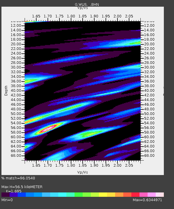
| Estimated Moho Depth: |
56.5 km |
| Estimated Crust Vp/Vs: |
1.70 |
| Assumed Crust Vp: |
6.353 km/s |
| Estimated Crust Vs: |
3.748 km/s |
| Estimated Crust Poisson's Ratio: |
0.23 |
|
| Radial Match: |
96.0548 % |
| Radial Bump: |
314 |
| Transverse Match: |
78.845116 % |
| Transverse Bump: |
400 |
| SOD ConfigId: |
16938 |
| Insert Time: |
2010-02-27 00:46:44.730 +0000 |
| GWidth: |
2.5 |
| Max Bumps: |
400 |
| Tol: |
0.001 |
|
Signal To Noise
| Channel | StoN | STA | LTA |
| G:WUS: :BHN:19910218T02:46:07.300012Z | 8.077377 | 4.4079502E-7 | 5.4571554E-8 |
| G:WUS: :BHE:19910218T02:46:07.300012Z | 15.364038 | 8.2186585E-7 | 5.3492826E-8 |
| G:WUS: :BHZ:19910218T02:46:07.300012Z | 31.041718 | 1.9556435E-6 | 6.300049E-8 |
| Arrivals |
| Ps | 6.5 SECOND |
| PpPs | 23 SECOND |
| PsPs/PpSs | 29 SECOND |


