You are here: Home > Network List > YB13 - Continental Dynamics/Cent. Anatolian Tectonics:Surface to Mantle Dynamics During Stations List
> Station AT62 Pinarbasi,Karaman,Turkey > Earthquake Result Viewer
AT62 Pinarbasi,Karaman,Turkey - Earthquake Result Viewer
| Earthquake location: |
South Indian Ocean |
| Earthquake latitude/longitude: |
-10.1/91.1 |
| Earthquake time(UTC): |
2014/06/14 (165) 11:11:00 GMT |
| Earthquake Depth: |
7.1 km |
| Earthquake Magnitude: |
6.4 MWP, 6.4 MWB |
| Earthquake Catalog/Contributor: |
NEIC PDE/NEIC COMCAT |
|
| Network: |
YB Continental Dynamics/Cent. Anatolian Tectonics:Surface to Mantle Dynamics During |
| Station: |
AT62 Pinarbasi,Karaman,Turkey |
| Lat/Lon: |
37.10 N/33.05 E |
| Elevation: |
1739 m |
|
| Distance: |
71.8 deg |
| Az: |
314.447 deg |
| Baz: |
118.43 deg |
| Ray Param: |
0.054119065 |
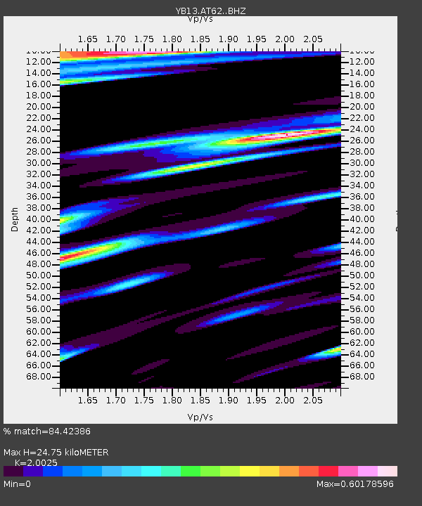
| Estimated Moho Depth: |
24.75 km |
| Estimated Crust Vp/Vs: |
2.00 |
| Assumed Crust Vp: |
6.247 km/s |
| Estimated Crust Vs: |
3.119 km/s |
| Estimated Crust Poisson's Ratio: |
0.33 |
|
| Radial Match: |
84.42386 % |
| Radial Bump: |
400 |
| Transverse Match: |
74.53837 % |
| Transverse Bump: |
400 |
| SOD ConfigId: |
3390531 |
| Insert Time: |
2019-04-12 06:30:36.408 +0000 |
| GWidth: |
2.5 |
| Max Bumps: |
400 |
| Tol: |
0.001 |
|

Signal To Noise
| Channel | StoN | STA | LTA |
| YB:AT62: :BHZ:20140614T11:21:52.600022Z | 27.76845 | 9.612647E-7 | 3.4617155E-8 |
| YB:AT62: :BHN:20140614T11:21:52.600022Z | 1.5255026 | 1.15443896E-7 | 7.567597E-8 |
| YB:AT62: :BHE:20140614T11:21:52.600022Z | 5.5873823 | 4.103363E-7 | 7.343981E-8 |
| Arrivals |
| Ps | 4.1 SECOND |
| PpPs | 12 SECOND |
| PsPs/PpSs | 16 SECOND |


