You are here: Home > Network List > G - GEOSCOPE Stations List
> Station WUS Wushi, Xinjiang Uygur, China > Earthquake Result Viewer
WUS Wushi, Xinjiang Uygur, China - Earthquake Result Viewer
| Earthquake location: |
New Britain Region, P.N.G. |
| Earthquake latitude/longitude: |
-5.6/150.2 |
| Earthquake time(UTC): |
1990/05/02 (122) 22:50:31 GMT |
| Earthquake Depth: |
96 km |
| Earthquake Magnitude: |
6.0 MB |
| Earthquake Catalog/Contributor: |
WHDF/NEIC |
|
| Network: |
G GEOSCOPE |
| Station: |
WUS Wushi, Xinjiang Uygur, China |
| Lat/Lon: |
41.20 N/79.22 E |
| Elevation: |
1457 m |
|
| Distance: |
79.5 deg |
| Az: |
313.51 deg |
| Baz: |
106.955 deg |
| Ray Param: |
0.04867505 |
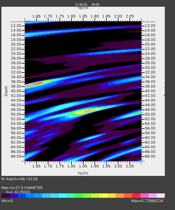
| Estimated Moho Depth: |
37.5 km |
| Estimated Crust Vp/Vs: |
1.61 |
| Assumed Crust Vp: |
6.353 km/s |
| Estimated Crust Vs: |
3.94 km/s |
| Estimated Crust Poisson's Ratio: |
0.19 |
|
| Radial Match: |
96.74155 % |
| Radial Bump: |
395 |
| Transverse Match: |
85.24281 % |
| Transverse Bump: |
400 |
| SOD ConfigId: |
16938 |
| Insert Time: |
2010-02-27 00:46:51.283 +0000 |
| GWidth: |
2.5 |
| Max Bumps: |
400 |
| Tol: |
0.001 |
|

Signal To Noise
| Channel | StoN | STA | LTA |
| G:WUS: :BHN:19900502T23:01:56.499011Z | 3.1337738 | 1.4174749E-7 | 4.52322E-8 |
| G:WUS: :BHE:19900502T23:01:56.499011Z | 8.346443 | 3.3599864E-7 | 4.0256502E-8 |
| G:WUS: :BHZ:19900502T23:01:56.499011Z | 25.91343 | 1.2107378E-6 | 4.6722406E-8 |
| Arrivals |
| Ps | 3.7 SECOND |
| PpPs | 15 SECOND |
| PsPs/PpSs | 19 SECOND |


