You are here: Home > Network List > CI - Caltech Regional Seismic Network Stations List
> Station SWS Sam W. Stewart, Westmorland, CA, USA > Earthquake Result Viewer
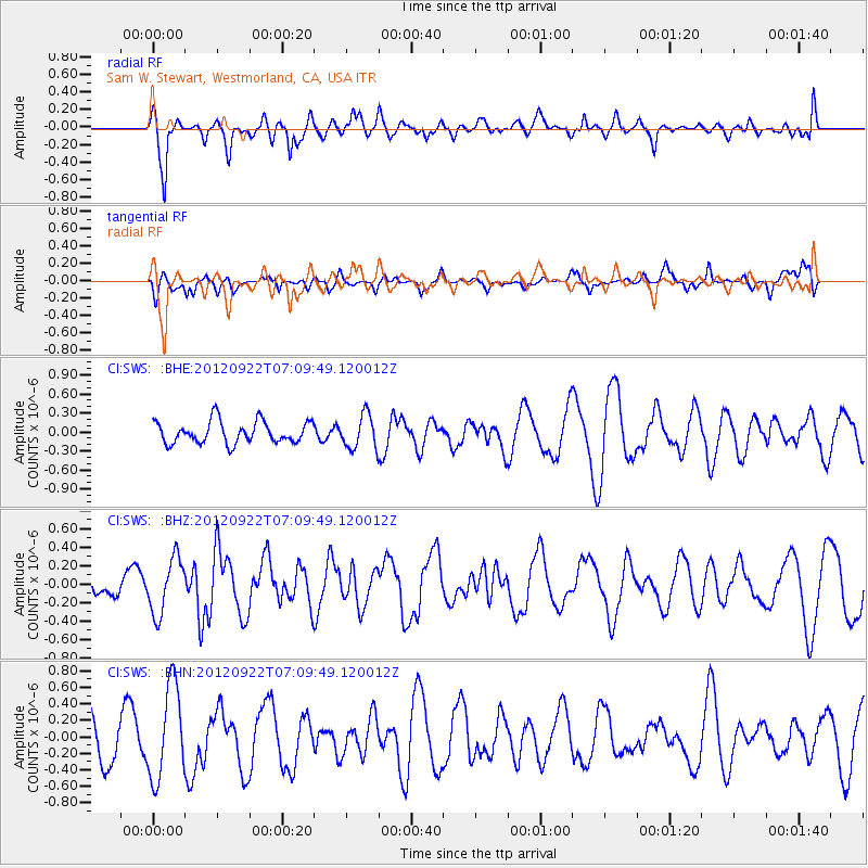
SWS Sam W. Stewart, Westmorland, CA, USA - Earthquake Result Viewer
*The percent match for this event was below the threshold and hence no stack was calculated.
| Earthquake location: |
Tonga Islands |
| Earthquake latitude/longitude: |
-20.9/-174.2 |
| Earthquake time(UTC): |
2012/09/22 (266) 06:58:26 GMT |
| Earthquake Depth: |
11 km |
| Earthquake Magnitude: |
5.5 MW, 5.1 MS, 5.4 MB, 5.6 MW |
| Earthquake Catalog/Contributor: |
WHDF/NEIC |
|
| Network: |
CI Caltech Regional Seismic Network |
| Station: |
SWS Sam W. Stewart, Westmorland, CA, USA |
| Lat/Lon: |
32.94 N/115.80 W |
| Elevation: |
140 m |
|
| Distance: |
77.3 deg |
| Az: |
47.24 deg |
| Baz: |
234.725 deg |
| Ray Param: |
$rayparam |
*The percent match for this event was below the threshold and hence was not used in the summary stack. |
|
| Radial Match: |
52.247913 % |
| Radial Bump: |
400 |
| Transverse Match: |
45.551777 % |
| Transverse Bump: |
378 |
| SOD ConfigId: |
476835 |
| Insert Time: |
2013-02-22 21:49:17.873 +0000 |
| GWidth: |
2.5 |
| Max Bumps: |
400 |
| Tol: |
0.001 |
|
Signal To Noise
| Channel | StoN | STA | LTA |
| CI:SWS: :BHZ:20120922T07:09:49.120012Z | 2.0925562 | 3.0110806E-7 | 1.4389484E-7 |
| CI:SWS: :BHN:20120922T07:09:49.120012Z | 2.6525726 | 5.674211E-7 | 2.1391351E-7 |
| CI:SWS: :BHE:20120922T07:09:49.120012Z | 1.5381198 | 2.676937E-7 | 1.7403956E-7 |
| Arrivals |
| Ps | |
| PpPs | |
| PsPs/PpSs | |


