You are here: Home > Network List > TA - USArray Transportable Network (new EarthScope stations) Stations List
> Station P39B Salisbury, MO, USA > Earthquake Result Viewer
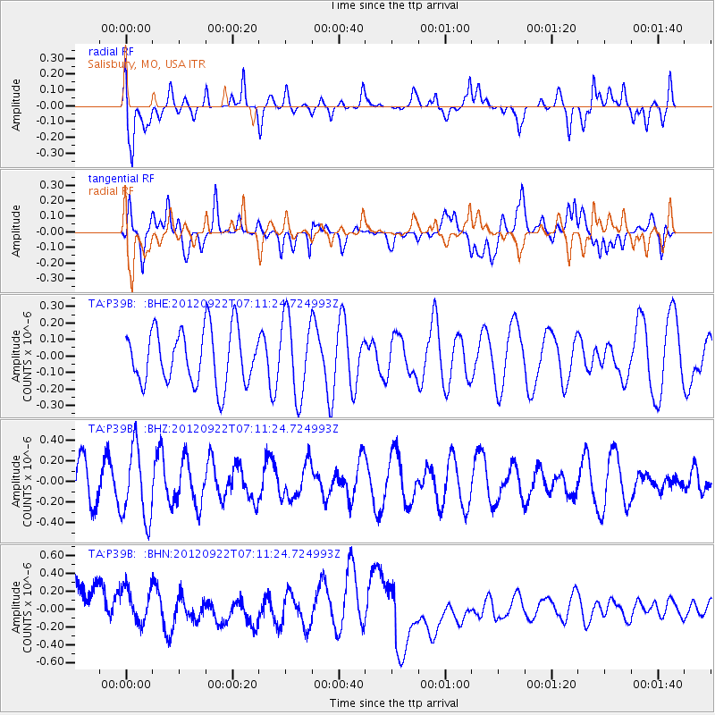
P39B Salisbury, MO, USA - Earthquake Result Viewer
*The percent match for this event was below the threshold and hence no stack was calculated.
| Earthquake location: |
Tonga Islands |
| Earthquake latitude/longitude: |
-20.9/-174.2 |
| Earthquake time(UTC): |
2012/09/22 (266) 06:58:26 GMT |
| Earthquake Depth: |
11 km |
| Earthquake Magnitude: |
5.5 MW, 5.1 MS, 5.4 MB, 5.6 MW |
| Earthquake Catalog/Contributor: |
WHDF/NEIC |
|
| Network: |
TA USArray Transportable Network (new EarthScope stations) |
| Station: |
P39B Salisbury, MO, USA |
| Lat/Lon: |
39.49 N/92.75 W |
| Elevation: |
226 m |
|
| Distance: |
96.7 deg |
| Az: |
50.4 deg |
| Baz: |
248.589 deg |
| Ray Param: |
$rayparam |
*The percent match for this event was below the threshold and hence was not used in the summary stack. |
|
| Radial Match: |
35.644703 % |
| Radial Bump: |
400 |
| Transverse Match: |
29.208248 % |
| Transverse Bump: |
400 |
| SOD ConfigId: |
476835 |
| Insert Time: |
2013-02-22 21:51:57.992 +0000 |
| GWidth: |
2.5 |
| Max Bumps: |
400 |
| Tol: |
0.001 |
|
Signal To Noise
| Channel | StoN | STA | LTA |
| TA:P39B: :BHZ:20120922T07:11:24.724993Z | 1.7856523 | 3.4877795E-7 | 1.9532243E-7 |
| TA:P39B: :BHN:20120922T07:11:24.724993Z | 1.0216855 | 2.5518864E-7 | 2.4977223E-7 |
| TA:P39B: :BHE:20120922T07:11:24.724993Z | 1.453063 | 2.4073208E-7 | 1.6567215E-7 |
| Arrivals |
| Ps | |
| PpPs | |
| PsPs/PpSs | |


