You are here: Home > Network List > TA - USArray Transportable Network (new EarthScope stations) Stations List
> Station C06D Leavenworth, WQ, USA > Earthquake Result Viewer
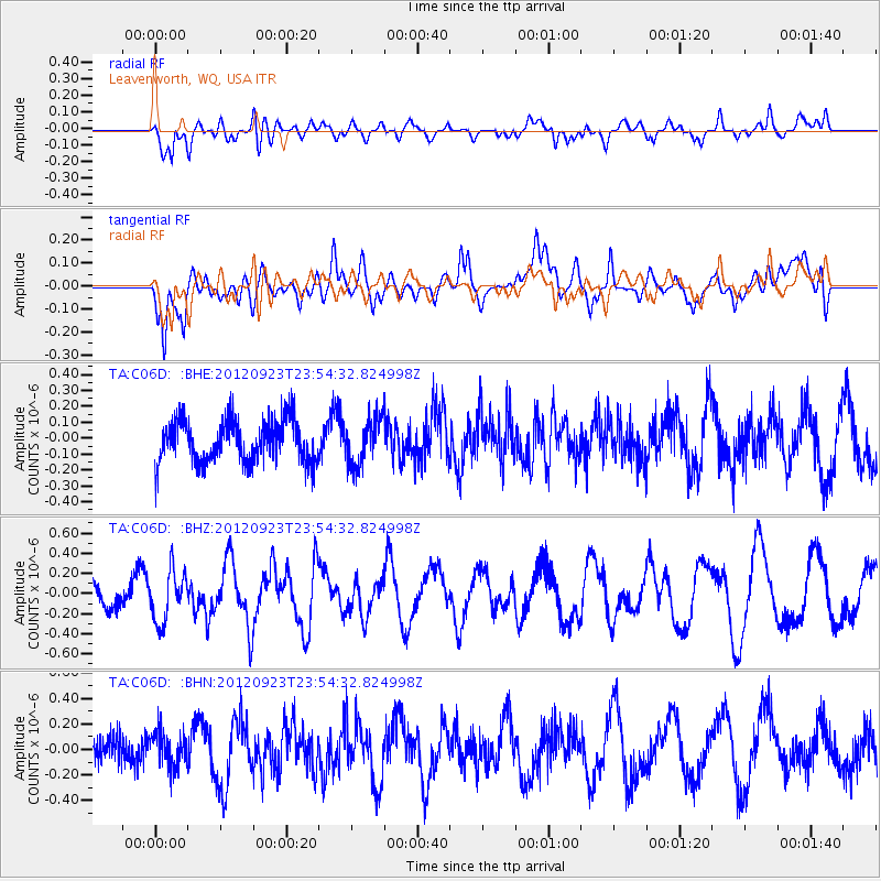
C06D Leavenworth, WQ, USA - Earthquake Result Viewer
*The percent match for this event was below the threshold and hence no stack was calculated.
| Earthquake location: |
South Of Mariana Islands |
| Earthquake latitude/longitude: |
11.7/143.2 |
| Earthquake time(UTC): |
2012/09/23 (267) 23:42:27 GMT |
| Earthquake Depth: |
8.8 km |
| Earthquake Magnitude: |
5.5 MB, 5.1 MS, 5.3 MW |
| Earthquake Catalog/Contributor: |
WHDF/NEIC |
|
| Network: |
TA USArray Transportable Network (new EarthScope stations) |
| Station: |
C06D Leavenworth, WQ, USA |
| Lat/Lon: |
47.92 N/120.89 W |
| Elevation: |
544 m |
|
| Distance: |
85.3 deg |
| Az: |
42.172 deg |
| Baz: |
282.136 deg |
| Ray Param: |
$rayparam |
*The percent match for this event was below the threshold and hence was not used in the summary stack. |
|
| Radial Match: |
70.670715 % |
| Radial Bump: |
400 |
| Transverse Match: |
51.908703 % |
| Transverse Bump: |
400 |
| SOD ConfigId: |
476835 |
| Insert Time: |
2013-02-22 21:58:25.290 +0000 |
| GWidth: |
2.5 |
| Max Bumps: |
400 |
| Tol: |
0.001 |
|
Signal To Noise
| Channel | StoN | STA | LTA |
| TA:C06D: :BHZ:20120923T23:54:32.824998Z | 1.6053939 | 2.5240692E-7 | 1.572243E-7 |
| TA:C06D: :BHN:20120923T23:54:32.824998Z | 1.2030544 | 1.5254105E-7 | 1.2679482E-7 |
| TA:C06D: :BHE:20120923T23:54:32.824998Z | 1.1039915 | 1.4481893E-7 | 1.3117757E-7 |
| Arrivals |
| Ps | |
| PpPs | |
| PsPs/PpSs | |


