You are here: Home > Network List > YB13 - Continental Dynamics/Cent. Anatolian Tectonics:Surface to Mantle Dynamics During Stations List
> Station AT05 Ormanici,Malatya,Turkey > Earthquake Result Viewer
AT05 Ormanici,Malatya,Turkey - Earthquake Result Viewer
| Earthquake location: |
Eastern Honshu, Japan |
| Earthquake latitude/longitude: |
39.5/141.0 |
| Earthquake time(UTC): |
2014/06/14 (165) 17:31:41 GMT |
| Earthquake Depth: |
92 km |
| Earthquake Magnitude: |
5.6 MWB, 5.6 MWC |
| Earthquake Catalog/Contributor: |
NEIC PDE/NEIC COMCAT |
|
| Network: |
YB Continental Dynamics/Cent. Anatolian Tectonics:Surface to Mantle Dynamics During |
| Station: |
AT05 Ormanici,Malatya,Turkey |
| Lat/Lon: |
38.22 N/38.79 E |
| Elevation: |
851 m |
|
| Distance: |
74.9 deg |
| Az: |
307.095 deg |
| Baz: |
51.627 deg |
| Ray Param: |
0.051844005 |
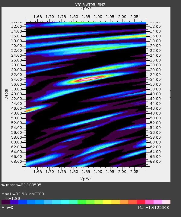
| Estimated Moho Depth: |
33.5 km |
| Estimated Crust Vp/Vs: |
1.86 |
| Assumed Crust Vp: |
6.35 km/s |
| Estimated Crust Vs: |
3.414 km/s |
| Estimated Crust Poisson's Ratio: |
0.30 |
|
| Radial Match: |
83.108505 % |
| Radial Bump: |
400 |
| Transverse Match: |
86.68066 % |
| Transverse Bump: |
400 |
| SOD ConfigId: |
3390531 |
| Insert Time: |
2019-04-12 06:39:25.848 +0000 |
| GWidth: |
2.5 |
| Max Bumps: |
400 |
| Tol: |
0.001 |
|

Signal To Noise
| Channel | StoN | STA | LTA |
| YB:AT05: :BHZ:20140614T17:42:41.180017Z | 16.714157 | 8.481661E-7 | 5.074537E-8 |
| YB:AT05: :BHN:20140614T17:42:41.180017Z | 4.2043004 | 1.8430435E-7 | 4.3837105E-8 |
| YB:AT05: :BHE:20140614T17:42:41.180017Z | 3.29144 | 2.1206834E-7 | 6.443026E-8 |
| Arrivals |
| Ps | 4.7 SECOND |
| PpPs | 15 SECOND |
| PsPs/PpSs | 19 SECOND |


