You are here: Home > Network List > YB13 - Continental Dynamics/Cent. Anatolian Tectonics:Surface to Mantle Dynamics During Stations List
> Station AT21 Asiklar,Nevsehir,Turkey > Earthquake Result Viewer
AT21 Asiklar,Nevsehir,Turkey - Earthquake Result Viewer
| Earthquake location: |
Eastern Honshu, Japan |
| Earthquake latitude/longitude: |
39.5/141.0 |
| Earthquake time(UTC): |
2014/06/14 (165) 17:31:41 GMT |
| Earthquake Depth: |
92 km |
| Earthquake Magnitude: |
5.6 MWB, 5.6 MWC |
| Earthquake Catalog/Contributor: |
NEIC PDE/NEIC COMCAT |
|
| Network: |
YB Continental Dynamics/Cent. Anatolian Tectonics:Surface to Mantle Dynamics During |
| Station: |
AT21 Asiklar,Nevsehir,Turkey |
| Lat/Lon: |
38.93 N/34.52 E |
| Elevation: |
1279 m |
|
| Distance: |
77.0 deg |
| Az: |
309.847 deg |
| Baz: |
49.645 deg |
| Ray Param: |
0.050414357 |
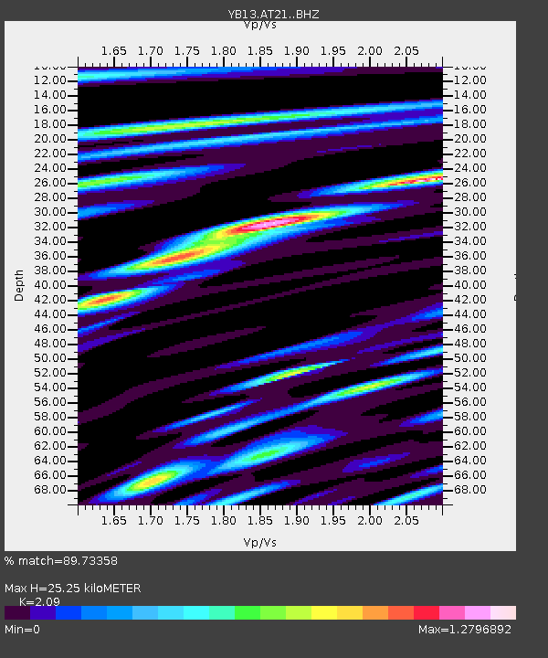
| Estimated Moho Depth: |
25.25 km |
| Estimated Crust Vp/Vs: |
2.09 |
| Assumed Crust Vp: |
6.35 km/s |
| Estimated Crust Vs: |
3.038 km/s |
| Estimated Crust Poisson's Ratio: |
0.35 |
|
| Radial Match: |
89.73358 % |
| Radial Bump: |
400 |
| Transverse Match: |
88.90326 % |
| Transverse Bump: |
400 |
| SOD ConfigId: |
3390531 |
| Insert Time: |
2019-04-12 06:39:37.500 +0000 |
| GWidth: |
2.5 |
| Max Bumps: |
400 |
| Tol: |
0.001 |
|

Signal To Noise
| Channel | StoN | STA | LTA |
| YB:AT21: :BHZ:20140614T17:42:53.279993Z | 38.19953 | 9.0830906E-7 | 2.3778016E-8 |
| YB:AT21: :BHN:20140614T17:42:53.279993Z | 6.41322 | 2.9129706E-7 | 4.5421338E-8 |
| YB:AT21: :BHE:20140614T17:42:53.279993Z | 7.7757144 | 2.5371708E-7 | 3.262942E-8 |
| Arrivals |
| Ps | 4.4 SECOND |
| PpPs | 12 SECOND |
| PsPs/PpSs | 16 SECOND |


