You are here: Home > Network List > TA - USArray Transportable Network (new EarthScope stations) Stations List
> Station G05D Wamic, OR, USA > Earthquake Result Viewer
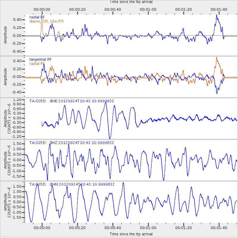
G05D Wamic, OR, USA - Earthquake Result Viewer
*The percent match for this event was below the threshold and hence no stack was calculated.
| Earthquake location: |
Tonga Islands |
| Earthquake latitude/longitude: |
-21.2/-174.3 |
| Earthquake time(UTC): |
2012/09/24 (268) 10:31:23 GMT |
| Earthquake Depth: |
10 km |
| Earthquake Magnitude: |
5.7 MB, 5.4 MS, 5.5 MW, 5.5 MW |
| Earthquake Catalog/Contributor: |
WHDF/NEIC |
|
| Network: |
TA USArray Transportable Network (new EarthScope stations) |
| Station: |
G05D Wamic, OR, USA |
| Lat/Lon: |
45.24 N/121.32 W |
| Elevation: |
592 m |
|
| Distance: |
81.8 deg |
| Az: |
34.74 deg |
| Baz: |
228.816 deg |
| Ray Param: |
$rayparam |
*The percent match for this event was below the threshold and hence was not used in the summary stack. |
|
| Radial Match: |
41.32111 % |
| Radial Bump: |
400 |
| Transverse Match: |
49.94018 % |
| Transverse Bump: |
400 |
| SOD ConfigId: |
478790 |
| Insert Time: |
2013-02-22 22:25:51.768 +0000 |
| GWidth: |
2.5 |
| Max Bumps: |
400 |
| Tol: |
0.001 |
|
Signal To Noise
| Channel | StoN | STA | LTA |
| TA:G05D: :BHZ:20120924T10:43:10.999983Z | 1.7361137 | 8.9879063E-7 | 5.1770263E-7 |
| TA:G05D: :BHN:20120924T10:43:10.999983Z | 0.90230155 | 9.656017E-7 | 1.0701541E-6 |
| TA:G05D: :BHE:20120924T10:43:10.999983Z | 1.1007205 | 4.2414422E-7 | 3.8533327E-7 |
| Arrivals |
| Ps | |
| PpPs | |
| PsPs/PpSs | |


