You are here: Home > Network List > YB13 - Continental Dynamics/Cent. Anatolian Tectonics:Surface to Mantle Dynamics During Stations List
> Station AT31 Inalli,Nevsehir,Turkey > Earthquake Result Viewer
AT31 Inalli,Nevsehir,Turkey - Earthquake Result Viewer
| Earthquake location: |
Eastern Honshu, Japan |
| Earthquake latitude/longitude: |
39.5/141.0 |
| Earthquake time(UTC): |
2014/06/14 (165) 17:31:41 GMT |
| Earthquake Depth: |
92 km |
| Earthquake Magnitude: |
5.6 MWB, 5.6 MWC |
| Earthquake Catalog/Contributor: |
NEIC PDE/NEIC COMCAT |
|
| Network: |
YB Continental Dynamics/Cent. Anatolian Tectonics:Surface to Mantle Dynamics During |
| Station: |
AT31 Inalli,Nevsehir,Turkey |
| Lat/Lon: |
38.57 N/34.51 E |
| Elevation: |
1303 m |
|
| Distance: |
77.2 deg |
| Az: |
309.579 deg |
| Baz: |
49.575 deg |
| Ray Param: |
0.050252996 |
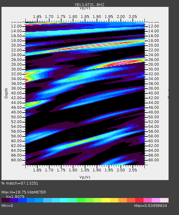
| Estimated Moho Depth: |
19.75 km |
| Estimated Crust Vp/Vs: |
1.91 |
| Assumed Crust Vp: |
6.35 km/s |
| Estimated Crust Vs: |
3.329 km/s |
| Estimated Crust Poisson's Ratio: |
0.31 |
|
| Radial Match: |
87.13251 % |
| Radial Bump: |
400 |
| Transverse Match: |
82.78141 % |
| Transverse Bump: |
400 |
| SOD ConfigId: |
3390531 |
| Insert Time: |
2019-04-12 06:39:43.239 +0000 |
| GWidth: |
2.5 |
| Max Bumps: |
400 |
| Tol: |
0.001 |
|

Signal To Noise
| Channel | StoN | STA | LTA |
| YB:AT31: :BHZ:20140614T17:42:54.62002Z | 14.051447 | 8.6166506E-7 | 6.132216E-8 |
| YB:AT31: :BHN:20140614T17:42:54.62002Z | 6.0880065 | 3.6247778E-7 | 5.9539648E-8 |
| YB:AT31: :BHE:20140614T17:42:54.62002Z | 4.529729 | 2.3623566E-7 | 5.2152274E-8 |
| Arrivals |
| Ps | 2.9 SECOND |
| PpPs | 8.8 SECOND |
| PsPs/PpSs | 12 SECOND |


