You are here: Home > Network List > G - GEOSCOPE Stations List
> Station WUS Wushi, Xinjiang Uygur, China > Earthquake Result Viewer
WUS Wushi, Xinjiang Uygur, China - Earthquake Result Viewer
| Earthquake location: |
Mindanao, Philippines |
| Earthquake latitude/longitude: |
8.3/126.5 |
| Earthquake time(UTC): |
1990/10/25 (298) 11:01:39 GMT |
| Earthquake Depth: |
53 km |
| Earthquake Magnitude: |
5.9 MB |
| Earthquake Catalog/Contributor: |
WHDF/NEIC |
|
| Network: |
G GEOSCOPE |
| Station: |
WUS Wushi, Xinjiang Uygur, China |
| Lat/Lon: |
41.20 N/79.22 E |
| Elevation: |
1457 m |
|
| Distance: |
53.1 deg |
| Az: |
316.094 deg |
| Baz: |
114.565 deg |
| Ray Param: |
0.066203006 |
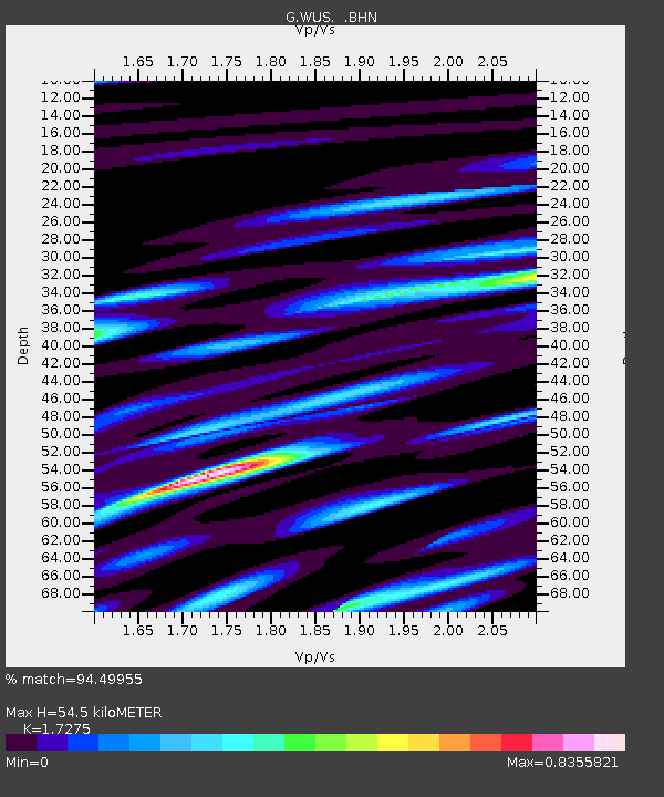
| Estimated Moho Depth: |
54.5 km |
| Estimated Crust Vp/Vs: |
1.73 |
| Assumed Crust Vp: |
6.353 km/s |
| Estimated Crust Vs: |
3.678 km/s |
| Estimated Crust Poisson's Ratio: |
0.25 |
|
| Radial Match: |
94.49955 % |
| Radial Bump: |
400 |
| Transverse Match: |
87.82877 % |
| Transverse Bump: |
400 |
| SOD ConfigId: |
17000 |
| Insert Time: |
2010-02-27 00:47:45.231 +0000 |
| GWidth: |
2.5 |
| Max Bumps: |
400 |
| Tol: |
0.001 |
|
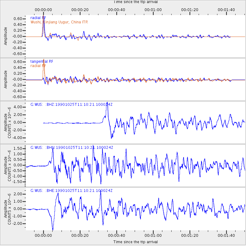
Signal To Noise
| Channel | StoN | STA | LTA |
| G:WUS: :BHN:19901025T11:10:21.100024Z | 10.037974 | 3.4686502E-7 | 3.455528E-8 |
| G:WUS: :BHE:19901025T11:10:21.100024Z | 15.146582 | 7.262793E-7 | 4.7950046E-8 |
| G:WUS: :BHZ:19901025T11:10:21.100024Z | 37.324306 | 1.799189E-6 | 4.8204218E-8 |
| Arrivals |
| Ps | 6.6 SECOND |
| PpPs | 22 SECOND |
| PsPs/PpSs | 29 SECOND |


