You are here: Home > Network List > YB13 - Continental Dynamics/Cent. Anatolian Tectonics:Surface to Mantle Dynamics During Stations List
> Station AT64 Esenpinar,Mersin,Turkey > Earthquake Result Viewer
AT64 Esenpinar,Mersin,Turkey - Earthquake Result Viewer
| Earthquake location: |
Eastern Honshu, Japan |
| Earthquake latitude/longitude: |
39.5/141.0 |
| Earthquake time(UTC): |
2014/06/14 (165) 17:31:41 GMT |
| Earthquake Depth: |
92 km |
| Earthquake Magnitude: |
5.6 MWB, 5.6 MWC |
| Earthquake Catalog/Contributor: |
NEIC PDE/NEIC COMCAT |
|
| Network: |
YB Continental Dynamics/Cent. Anatolian Tectonics:Surface to Mantle Dynamics During |
| Station: |
AT64 Esenpinar,Mersin,Turkey |
| Lat/Lon: |
36.60 N/34.12 E |
| Elevation: |
874 m |
|
| Distance: |
78.8 deg |
| Az: |
308.259 deg |
| Baz: |
49.065 deg |
| Ray Param: |
0.04922745 |
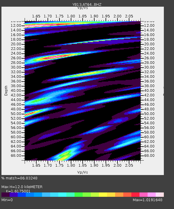
| Estimated Moho Depth: |
12.0 km |
| Estimated Crust Vp/Vs: |
1.62 |
| Assumed Crust Vp: |
6.247 km/s |
| Estimated Crust Vs: |
3.862 km/s |
| Estimated Crust Poisson's Ratio: |
0.19 |
|
| Radial Match: |
86.83248 % |
| Radial Bump: |
400 |
| Transverse Match: |
87.007515 % |
| Transverse Bump: |
400 |
| SOD ConfigId: |
3390531 |
| Insert Time: |
2019-04-12 06:40:02.113 +0000 |
| GWidth: |
2.5 |
| Max Bumps: |
400 |
| Tol: |
0.001 |
|

Signal To Noise
| Channel | StoN | STA | LTA |
| YB:AT64: :BHZ:20140614T17:43:02.959009Z | 14.958115 | 8.383632E-7 | 5.6047384E-8 |
| YB:AT64: :BHN:20140614T17:43:02.959009Z | 9.654702 | 3.4688665E-7 | 3.5929293E-8 |
| YB:AT64: :BHE:20140614T17:43:02.959009Z | 9.645774 | 2.995536E-7 | 3.105542E-8 |
| Arrivals |
| Ps | 1.2 SECOND |
| PpPs | 4.9 SECOND |
| PsPs/PpSs | 6.1 SECOND |


