You are here: Home > Network List > GE - GEOFON Stations List
> Station SUMG GEOFON Station Summit Camp, Greenland > Earthquake Result Viewer
SUMG GEOFON Station Summit Camp, Greenland - Earthquake Result Viewer
| Earthquake location: |
Baja California, Mexico |
| Earthquake latitude/longitude: |
24.7/-110.2 |
| Earthquake time(UTC): |
2012/09/25 (269) 23:45:24 GMT |
| Earthquake Depth: |
10 km |
| Earthquake Magnitude: |
5.9 MB, 6.1 MS, 6.3 MW, 6.3 MW |
| Earthquake Catalog/Contributor: |
WHDF/NEIC |
|
| Network: |
GE GEOFON |
| Station: |
SUMG GEOFON Station Summit Camp, Greenland |
| Lat/Lon: |
72.58 N/38.45 W |
| Elevation: |
3240 m |
|
| Distance: |
61.2 deg |
| Az: |
19.053 deg |
| Baz: |
260.337 deg |
| Ray Param: |
0.06102685 |
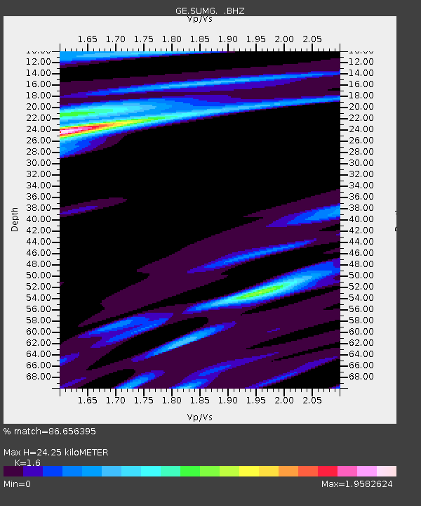
| Estimated Moho Depth: |
24.25 km |
| Estimated Crust Vp/Vs: |
1.60 |
| Assumed Crust Vp: |
6.261 km/s |
| Estimated Crust Vs: |
3.913 km/s |
| Estimated Crust Poisson's Ratio: |
0.18 |
|
| Radial Match: |
86.656395 % |
| Radial Bump: |
400 |
| Transverse Match: |
56.9205 % |
| Transverse Bump: |
400 |
| SOD ConfigId: |
478790 |
| Insert Time: |
2013-02-22 22:45:36.717 +0000 |
| GWidth: |
2.5 |
| Max Bumps: |
400 |
| Tol: |
0.001 |
|

Signal To Noise
| Channel | StoN | STA | LTA |
| GE:SUMG: :BHZ:20120925T23:55:08.695005Z | 9.026366 | 5.8589817E-6 | 6.490964E-7 |
| GE:SUMG: :BHN:20120925T23:55:08.695005Z | 1.2719308 | 9.727702E-7 | 7.647981E-7 |
| GE:SUMG: :BHE:20120925T23:55:08.695005Z | 3.545915 | 2.276365E-6 | 6.419683E-7 |
| Arrivals |
| Ps | 2.4 SECOND |
| PpPs | 9.6 SECOND |
| PsPs/PpSs | 12 SECOND |


