You are here: Home > Network List > NE - New England Seismic Network Stations List
> Station WES Weston Observatory, Weston, MA, USA > Earthquake Result Viewer
WES Weston Observatory, Weston, MA, USA - Earthquake Result Viewer
| Earthquake location: |
Baja California, Mexico |
| Earthquake latitude/longitude: |
24.7/-110.2 |
| Earthquake time(UTC): |
2012/09/25 (269) 23:45:24 GMT |
| Earthquake Depth: |
10 km |
| Earthquake Magnitude: |
5.9 MB, 6.1 MS, 6.3 MW, 6.3 MW |
| Earthquake Catalog/Contributor: |
WHDF/NEIC |
|
| Network: |
NE New England Seismic Network |
| Station: |
WES Weston Observatory, Weston, MA, USA |
| Lat/Lon: |
42.38 N/71.32 W |
| Elevation: |
60 m |
|
| Distance: |
36.5 deg |
| Az: |
51.355 deg |
| Baz: |
253.56 deg |
| Ray Param: |
0.07663794 |
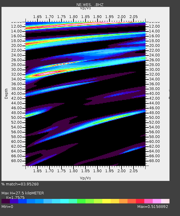
| Estimated Moho Depth: |
27.5 km |
| Estimated Crust Vp/Vs: |
1.76 |
| Assumed Crust Vp: |
6.419 km/s |
| Estimated Crust Vs: |
3.652 km/s |
| Estimated Crust Poisson's Ratio: |
0.26 |
|
| Radial Match: |
83.95268 % |
| Radial Bump: |
400 |
| Transverse Match: |
50.356453 % |
| Transverse Bump: |
400 |
| SOD ConfigId: |
478790 |
| Insert Time: |
2013-02-22 22:49:01.813 +0000 |
| GWidth: |
2.5 |
| Max Bumps: |
400 |
| Tol: |
0.001 |
|

Signal To Noise
| Channel | StoN | STA | LTA |
| NE:WES: :BHZ:20120925T23:51:59.614988Z | 5.354614 | 1.6190838E-6 | 3.0237175E-7 |
| NE:WES: :BHN:20120925T23:51:59.614988Z | 2.7391832 | 4.6960525E-7 | 1.714399E-7 |
| NE:WES: :BHE:20120925T23:51:59.614988Z | 3.6717682 | 8.106171E-7 | 2.2077023E-7 |
| Arrivals |
| Ps | 3.5 SECOND |
| PpPs | 11 SECOND |
| PsPs/PpSs | 14 SECOND |


