You are here: Home > Network List > TA - USArray Transportable Network (new EarthScope stations) Stations List
> Station N59A State Game Land 141, Hazleton, PA, USA > Earthquake Result Viewer
N59A State Game Land 141, Hazleton, PA, USA - Earthquake Result Viewer
| Earthquake location: |
Baja California, Mexico |
| Earthquake latitude/longitude: |
24.7/-110.2 |
| Earthquake time(UTC): |
2012/09/25 (269) 23:45:24 GMT |
| Earthquake Depth: |
10 km |
| Earthquake Magnitude: |
5.9 MB, 6.1 MS, 6.3 MW, 6.3 MW |
| Earthquake Catalog/Contributor: |
WHDF/NEIC |
|
| Network: |
TA USArray Transportable Network (new EarthScope stations) |
| Station: |
N59A State Game Land 141, Hazleton, PA, USA |
| Lat/Lon: |
40.92 N/75.77 W |
| Elevation: |
508 m |
|
| Distance: |
32.9 deg |
| Az: |
52.035 deg |
| Baz: |
251.173 deg |
| Ray Param: |
0.07845724 |
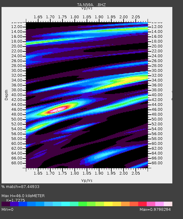
| Estimated Moho Depth: |
46.0 km |
| Estimated Crust Vp/Vs: |
1.73 |
| Assumed Crust Vp: |
6.283 km/s |
| Estimated Crust Vs: |
3.637 km/s |
| Estimated Crust Poisson's Ratio: |
0.25 |
|
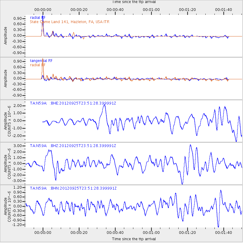
| Radial Match: |
87.44933 % |
| Radial Bump: |
315 |
| Transverse Match: |
64.844955 % |
| Transverse Bump: |
400 |
| SOD ConfigId: |
478790 |
| Insert Time: |
2013-02-22 22:52:39.686 +0000 |
| GWidth: |
2.5 |
| Max Bumps: |
400 |
| Tol: |
0.001 |
|
Signal To Noise
| Channel | StoN | STA | LTA |
| TA:N59A: :BHZ:20120925T23:51:28.399991Z | 6.393852 | 1.5957679E-6 | 2.4957848E-7 |
| TA:N59A: :BHN:20120925T23:51:28.399991Z | 2.1424012 | 3.9530025E-7 | 1.8451271E-7 |
| TA:N59A: :BHE:20120925T23:51:28.399991Z | 5.233042 | 1.2822853E-6 | 2.4503632E-7 |
| Arrivals |
| Ps | 5.8 SECOND |
| PpPs | 18 SECOND |
| PsPs/PpSs | 24 SECOND |


