You are here: Home > Network List > TA - USArray Transportable Network (new EarthScope stations) Stations List
> Station D54A Lac Fusel, La Vallee-de-La-Gatineau, QC, CAN > Earthquake Result Viewer
D54A Lac Fusel, La Vallee-de-La-Gatineau, QC, CAN - Earthquake Result Viewer
| Earthquake location: |
Baja California, Mexico |
| Earthquake latitude/longitude: |
24.7/-110.2 |
| Earthquake time(UTC): |
2012/09/25 (269) 23:45:24 GMT |
| Earthquake Depth: |
10 km |
| Earthquake Magnitude: |
5.9 MB, 6.1 MS, 6.3 MW, 6.3 MW |
| Earthquake Catalog/Contributor: |
WHDF/NEIC |
|
| Network: |
TA USArray Transportable Network (new EarthScope stations) |
| Station: |
D54A Lac Fusel, La Vallee-de-La-Gatineau, QC, CAN |
| Lat/Lon: |
47.15 N/76.66 W |
| Elevation: |
415 m |
|
| Distance: |
34.8 deg |
| Az: |
41.311 deg |
| Baz: |
241.643 deg |
| Ray Param: |
0.07754867 |
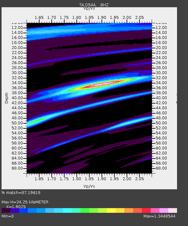
| Estimated Moho Depth: |
34.25 km |
| Estimated Crust Vp/Vs: |
1.90 |
| Assumed Crust Vp: |
6.622 km/s |
| Estimated Crust Vs: |
3.481 km/s |
| Estimated Crust Poisson's Ratio: |
0.31 |
|
| Radial Match: |
87.19618 % |
| Radial Bump: |
257 |
| Transverse Match: |
59.803543 % |
| Transverse Bump: |
400 |
| SOD ConfigId: |
478790 |
| Insert Time: |
2013-02-22 22:53:12.459 +0000 |
| GWidth: |
2.5 |
| Max Bumps: |
400 |
| Tol: |
0.001 |
|

Signal To Noise
| Channel | StoN | STA | LTA |
| TA:D54A: :BHZ:20120925T23:51:44.999998Z | 4.532166 | 1.9242273E-6 | 4.245712E-7 |
| TA:D54A: :BHN:20120925T23:51:44.999998Z | 3.4239674 | 6.0094004E-7 | 1.7550987E-7 |
| TA:D54A: :BHE:20120925T23:51:44.999998Z | 3.074023 | 1.0325718E-6 | 3.3590246E-7 |
| Arrivals |
| Ps | 5.0 SECOND |
| PpPs | 14 SECOND |
| PsPs/PpSs | 19 SECOND |


