You are here: Home > Network List > G - GEOSCOPE Stations List
> Station WUS Wushi, Xinjiang Uygur, China > Earthquake Result Viewer
WUS Wushi, Xinjiang Uygur, China - Earthquake Result Viewer
| Earthquake location: |
Alaska Peninsula |
| Earthquake latitude/longitude: |
54.5/-161.6 |
| Earthquake time(UTC): |
1991/05/30 (150) 13:17:44 GMT |
| Earthquake Depth: |
47 km |
| Earthquake Magnitude: |
6.2 MB, 6.7 MS, 6.8 UNKNOWN |
| Earthquake Catalog/Contributor: |
WHDF/NEIC |
|
| Network: |
G GEOSCOPE |
| Station: |
WUS Wushi, Xinjiang Uygur, China |
| Lat/Lon: |
41.20 N/79.22 E |
| Elevation: |
1457 m |
|
| Distance: |
71.4 deg |
| Az: |
315.976 deg |
| Baz: |
32.468 deg |
| Ray Param: |
0.054248795 |
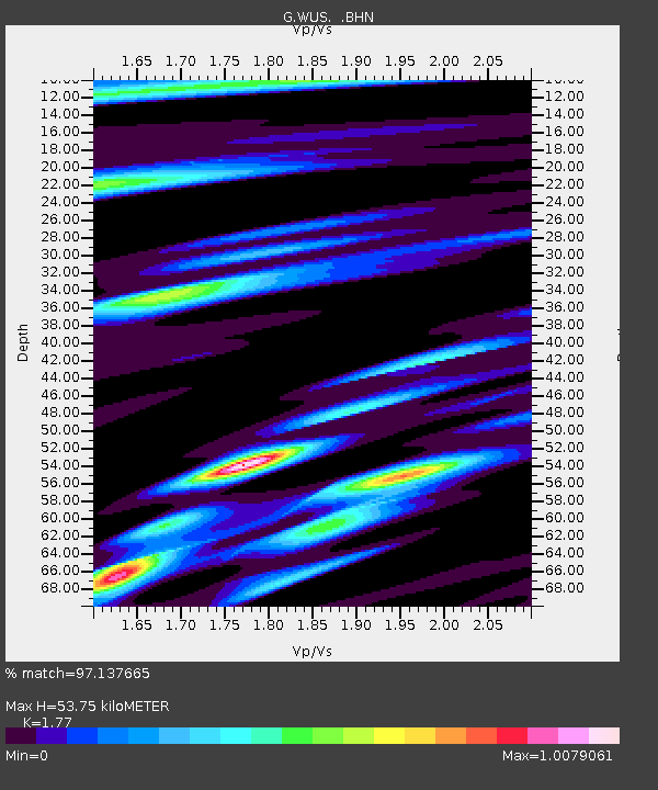
| Estimated Moho Depth: |
53.75 km |
| Estimated Crust Vp/Vs: |
1.77 |
| Assumed Crust Vp: |
6.353 km/s |
| Estimated Crust Vs: |
3.589 km/s |
| Estimated Crust Poisson's Ratio: |
0.27 |
|
| Radial Match: |
97.137665 % |
| Radial Bump: |
400 |
| Transverse Match: |
92.17782 % |
| Transverse Bump: |
400 |
| SOD ConfigId: |
16938 |
| Insert Time: |
2010-02-27 00:48:18.296 +0000 |
| GWidth: |
2.5 |
| Max Bumps: |
400 |
| Tol: |
0.001 |
|

Signal To Noise
| Channel | StoN | STA | LTA |
| G:WUS: :BHN:19910530T13:28:28.600Z | 40.169106 | 1.2629251E-6 | 3.1440212E-8 |
| G:WUS: :BHE:19910530T13:28:28.600Z | 22.674747 | 1.0849997E-6 | 4.7850573E-8 |
| G:WUS: :BHZ:19910530T13:28:28.600Z | 53.142284 | 3.936372E-6 | 7.407232E-8 |
| Arrivals |
| Ps | 6.7 SECOND |
| PpPs | 23 SECOND |
| PsPs/PpSs | 29 SECOND |


