You are here: Home > Network List > G - GEOSCOPE Stations List
> Station WUS Wushi, Xinjiang Uygur, China > Earthquake Result Viewer
WUS Wushi, Xinjiang Uygur, China - Earthquake Result Viewer
| Earthquake location: |
Timor Region |
| Earthquake latitude/longitude: |
-8.1/124.7 |
| Earthquake time(UTC): |
1991/07/04 (185) 11:43:11 GMT |
| Earthquake Depth: |
33 km |
| Earthquake Magnitude: |
6.2 MB, 6.4 MS |
| Earthquake Catalog/Contributor: |
WHDF/NEIC |
|
| Network: |
G GEOSCOPE |
| Station: |
WUS Wushi, Xinjiang Uygur, China |
| Lat/Lon: |
41.20 N/79.22 E |
| Elevation: |
1457 m |
|
| Distance: |
64.4 deg |
| Az: |
323.401 deg |
| Baz: |
128.531 deg |
| Ray Param: |
0.058897484 |
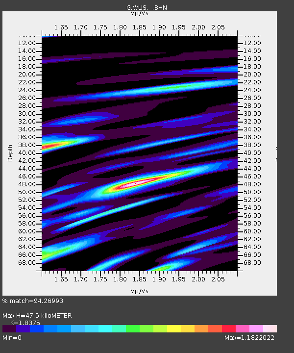
| Estimated Moho Depth: |
47.5 km |
| Estimated Crust Vp/Vs: |
1.84 |
| Assumed Crust Vp: |
6.353 km/s |
| Estimated Crust Vs: |
3.457 km/s |
| Estimated Crust Poisson's Ratio: |
0.29 |
|
| Radial Match: |
94.26993 % |
| Radial Bump: |
400 |
| Transverse Match: |
88.715515 % |
| Transverse Bump: |
400 |
| SOD ConfigId: |
16938 |
| Insert Time: |
2010-02-27 00:48:33.927 +0000 |
| GWidth: |
2.5 |
| Max Bumps: |
400 |
| Tol: |
0.001 |
|

Signal To Noise
| Channel | StoN | STA | LTA |
| G:WUS: :BHN:19910704T11:53:13.050012Z | 14.856163 | 2.7968053E-7 | 1.8825894E-8 |
| G:WUS: :BHE:19910704T11:53:13.050012Z | 12.878825 | 3.3772218E-7 | 2.6223058E-8 |
| G:WUS: :BHZ:19910704T11:53:13.050012Z | 23.709442 | 1.0076393E-6 | 4.2499494E-8 |
| Arrivals |
| Ps | 6.5 SECOND |
| PpPs | 20 SECOND |
| PsPs/PpSs | 27 SECOND |


