You are here: Home > Network List > CI - Caltech Regional Seismic Network Stations List
> Station ADO Adelanto Receiving Station, Victorville, CA, USA > Earthquake Result Viewer
ADO Adelanto Receiving Station, Victorville, CA, USA - Earthquake Result Viewer
| Earthquake location: |
Andreanof Islands, Aleutian Is. |
| Earthquake latitude/longitude: |
51.6/-178.3 |
| Earthquake time(UTC): |
2012/09/26 (270) 23:39:55 GMT |
| Earthquake Depth: |
16 km |
| Earthquake Magnitude: |
6.3 MB, 6.5 MS, 6.4 MW, 6.4 MW |
| Earthquake Catalog/Contributor: |
WHDF/NEIC |
|
| Network: |
CI Caltech Regional Seismic Network |
| Station: |
ADO Adelanto Receiving Station, Victorville, CA, USA |
| Lat/Lon: |
34.55 N/117.43 W |
| Elevation: |
908 m |
|
| Distance: |
46.2 deg |
| Az: |
86.979 deg |
| Baz: |
310.999 deg |
| Ray Param: |
0.07076724 |
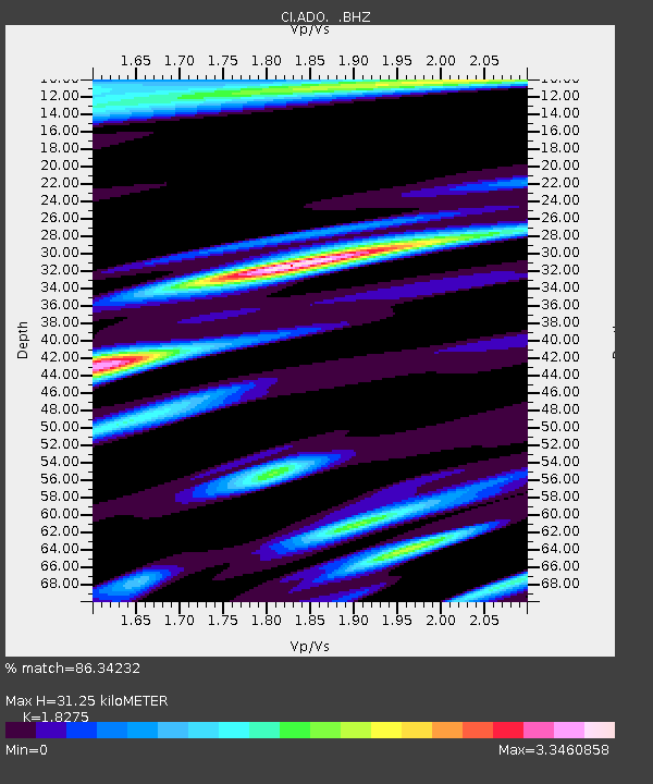
| Estimated Moho Depth: |
31.25 km |
| Estimated Crust Vp/Vs: |
1.83 |
| Assumed Crust Vp: |
6.276 km/s |
| Estimated Crust Vs: |
3.434 km/s |
| Estimated Crust Poisson's Ratio: |
0.29 |
|
| Radial Match: |
86.34232 % |
| Radial Bump: |
400 |
| Transverse Match: |
88.38785 % |
| Transverse Bump: |
346 |
| SOD ConfigId: |
478790 |
| Insert Time: |
2013-02-22 23:03:34.610 +0000 |
| GWidth: |
2.5 |
| Max Bumps: |
400 |
| Tol: |
0.001 |
|

Signal To Noise
| Channel | StoN | STA | LTA |
| CI:ADO: :BHZ:20120926T23:47:48.344985Z | 7.935635 | 3.0384394E-6 | 3.8288547E-7 |
| CI:ADO: :BHN:20120926T23:47:48.344985Z | 4.834889 | 2.6078924E-6 | 5.393903E-7 |
| CI:ADO: :BHE:20120926T23:47:48.344985Z | 0.96995074 | 8.300058E-7 | 8.557195E-7 |
| Arrivals |
| Ps | 4.4 SECOND |
| PpPs | 13 SECOND |
| PsPs/PpSs | 18 SECOND |


