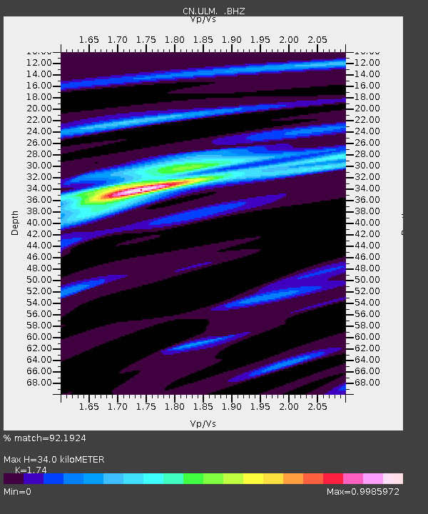
ULM LAC DU BONNET, MB - Earthquake Result Viewer

Earthquake location: Andreanof Islands, Aleutian Is.
Earthquake latitude/longitude: 51.6/-178.3
Earthquake time(UTC): 2012/09/26 (270) 23:39:55 GMT
Earthquake Depth: 16 km
Earthquake Magnitude: 6.3 MB, 6.5 MS, 6.4 MW, 6.4 MW
Earthquake Catalog/Contributor: WHDF/NEIC
Network: CN Canadian National Seismograph Network
Station: ULM LAC DU BONNET, MB
Lat/Lon: 50.25 N/95.88 W
Elevation: 251 m
Distance: 49.3 deg
Az: 57.073 deg
Baz: 305.351 deg
Ray Param: 0.06877214
Estimated Moho Depth: 34.0 km
Estimated Crust Vp/Vs: 1.74
Assumed Crust Vp: 6.459 km/s
Estimated Crust Vs: 3.712 km/s
Estimated Crust Poisson's Ratio: 0.25
Radial Match: 92.1924 %
Radial Bump: 225
Transverse Match: 57.309532 %
Transverse Bump: 400
SOD ConfigId: 478790
Insert Time: 2013-02-22 23:05:58.629 +0000
GWidth: 2.5
Max Bumps: 400
Tol: 0.001

Signal To Noise

ChannelStoNSTALTA
CN:ULM: :BHZ:20120926T23:48:12.250015Z8.7878911.2421341E-61.4134608E-7
CN:ULM: :BHN:20120926T23:48:12.250015Z4.2498224.121433E-79.697895E-8
CN:ULM: :BHE:20120926T23:48:12.250015Z4.4252535.18217E-71.1710449E-7
Arrivals
Ps4.1 SECOND
PpPs14 SECOND
PsPs/PpSs18 SECOND