You are here: Home > Network List > G - GEOSCOPE Stations List
> Station WUS Wushi, Xinjiang Uygur, China > Earthquake Result Viewer
WUS Wushi, Xinjiang Uygur, China - Earthquake Result Viewer
| Earthquake location: |
Southeast Of Honshu, Japan |
| Earthquake latitude/longitude: |
33.6/138.8 |
| Earthquake time(UTC): |
1991/09/03 (246) 08:44:47 GMT |
| Earthquake Depth: |
23 km |
| Earthquake Magnitude: |
5.9 MB, 6.4 MS, 6.0 UNKNOWN |
| Earthquake Catalog/Contributor: |
WHDF/NEIC |
|
| Network: |
G GEOSCOPE |
| Station: |
WUS Wushi, Xinjiang Uygur, China |
| Lat/Lon: |
41.20 N/79.22 E |
| Elevation: |
1457 m |
|
| Distance: |
47.1 deg |
| Az: |
297.352 deg |
| Baz: |
79.074 deg |
| Ray Param: |
0.070181005 |
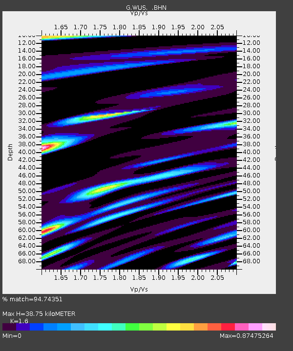
| Estimated Moho Depth: |
38.75 km |
| Estimated Crust Vp/Vs: |
1.60 |
| Assumed Crust Vp: |
6.353 km/s |
| Estimated Crust Vs: |
3.971 km/s |
| Estimated Crust Poisson's Ratio: |
0.18 |
|
| Radial Match: |
94.74351 % |
| Radial Bump: |
352 |
| Transverse Match: |
86.38499 % |
| Transverse Bump: |
400 |
| SOD ConfigId: |
16938 |
| Insert Time: |
2010-02-27 00:48:41.524 +0000 |
| GWidth: |
2.5 |
| Max Bumps: |
400 |
| Tol: |
0.001 |
|

Signal To Noise
| Channel | StoN | STA | LTA |
| G:WUS: :BHN:19910903T08:52:47.150Z | 2.399701 | 9.949245E-8 | 4.146035E-8 |
| G:WUS: :BHE:19910903T08:52:47.150Z | 9.4936905 | 2.971506E-7 | 3.12998E-8 |
| G:WUS: :BHZ:19910903T08:52:47.150Z | 8.480867 | 5.587211E-7 | 6.588018E-8 |
| Arrivals |
| Ps | 3.9 SECOND |
| PpPs | 15 SECOND |
| PsPs/PpSs | 19 SECOND |


