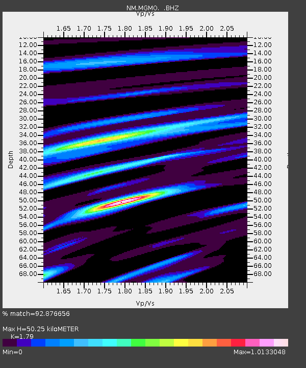
MGMO Mountain Grove, MO - Earthquake Result Viewer

Earthquake location: Andreanof Islands, Aleutian Is.
Earthquake latitude/longitude: 51.6/-178.3
Earthquake time(UTC): 2012/09/26 (270) 23:39:55 GMT
Earthquake Depth: 16 km
Earthquake Magnitude: 6.3 MB, 6.5 MS, 6.4 MW, 6.4 MW
Earthquake Catalog/Contributor: WHDF/NEIC
Network: NM Cooperative New Madrid Seismic Network
Station: MGMO Mountain Grove, MO
Lat/Lon: 37.15 N/92.27 W
Elevation: 453 m
Distance: 59.7 deg
Az: 67.394 deg
Baz: 313.88 deg
Ray Param: 0.062003665
Estimated Moho Depth: 50.25 km
Estimated Crust Vp/Vs: 1.79
Assumed Crust Vp: 6.53 km/s
Estimated Crust Vs: 3.648 km/s
Estimated Crust Poisson's Ratio: 0.27
Radial Match: 92.876656 %
Radial Bump: 371
Transverse Match: 73.211754 %
Transverse Bump: 400
SOD ConfigId: 478790
Insert Time: 2013-02-22 23:12:34.567 +0000
GWidth: 2.5
Max Bumps: 400
Tol: 0.001

Signal To Noise

ChannelStoNSTALTA
NM:MGMO: :BHZ:20120926T23:49:27.644973Z21.1722981.5251901E-67.203706E-8
NM:MGMO: :BHN:20120926T23:49:27.644973Z8.5165136.2050003E-77.285846E-8
NM:MGMO: :BHE:20120926T23:49:27.644973Z6.34220364.940107E-77.7892594E-8
Arrivals
Ps6.4 SECOND
PpPs20 SECOND
PsPs/PpSs27 SECOND