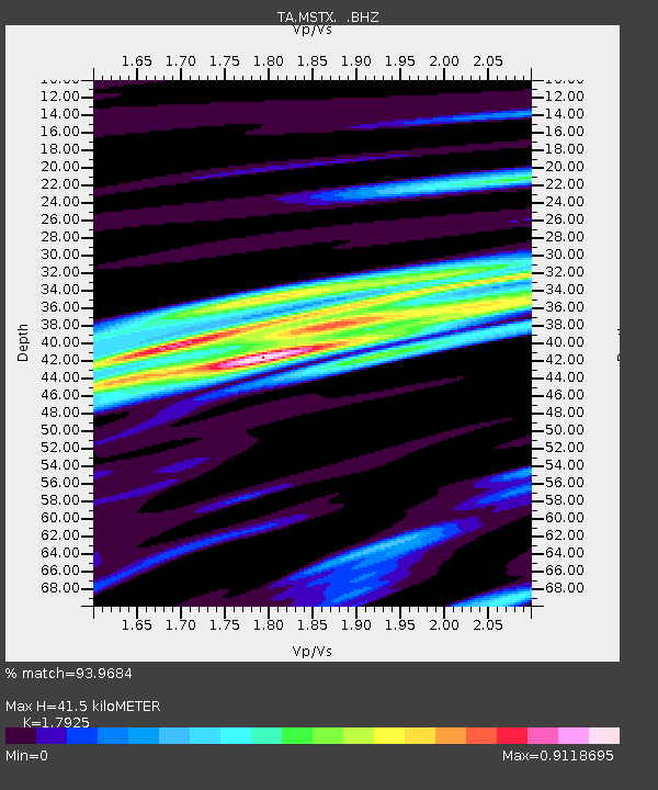
MSTX Muleshoe, TX, USA - Earthquake Result Viewer
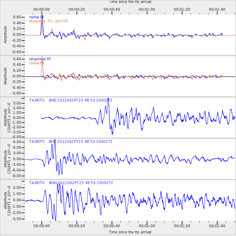
Earthquake location: Andreanof Islands, Aleutian Is.
Earthquake latitude/longitude: 51.6/-178.3
Earthquake time(UTC): 2012/09/26 (270) 23:39:55 GMT
Earthquake Depth: 16 km
Earthquake Magnitude: 6.3 MB, 6.5 MS, 6.4 MW, 6.4 MW
Earthquake Catalog/Contributor: WHDF/NEIC
Network: TA USArray Transportable Network (new EarthScope stations)
Station: MSTX Muleshoe, TX, USA
Lat/Lon: 33.97 N/102.77 W
Elevation: 1167 m
Distance: 55.6 deg
Az: 77.082 deg
Baz: 312.977 deg
Ray Param: 0.064643055
Estimated Moho Depth: 41.5 km
Estimated Crust Vp/Vs: 1.79
Assumed Crust Vp: 6.129 km/s
Estimated Crust Vs: 3.419 km/s
Estimated Crust Poisson's Ratio: 0.27
Radial Match: 93.9684 %
Radial Bump: 360
Transverse Match: 74.090614 %
Transverse Bump: 400
SOD ConfigId: 478790
Insert Time: 2013-02-22 23:16:16.524 +0000
GWidth: 2.5
Max Bumps: 400
Tol: 0.001

Signal To Noise

ChannelStoNSTALTA
TA:MSTX: :BHZ:20120926T23:48:59.200027Z14.472912.1413225E-61.4795384E-7
TA:MSTX: :BHN:20120926T23:48:59.200027Z9.4423579.568685E-71.01337875E-7
TA:MSTX: :BHE:20120926T23:48:59.200027Z5.6692867.7022116E-71.358586E-7
Arrivals
Ps5.6 SECOND
PpPs18 SECOND
PsPs/PpSs24 SECOND