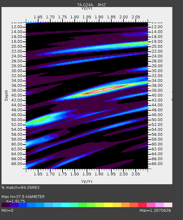
Q24A Divide, CO, USA - Earthquake Result Viewer

Earthquake location: Andreanof Islands, Aleutian Is.
Earthquake latitude/longitude: 51.6/-178.3
Earthquake time(UTC): 2012/09/26 (270) 23:39:55 GMT
Earthquake Depth: 16 km
Earthquake Magnitude: 6.3 MB, 6.5 MS, 6.4 MW, 6.4 MW
Earthquake Catalog/Contributor: WHDF/NEIC
Network: TA USArray Transportable Network (new EarthScope stations)
Station: Q24A Divide, CO, USA
Lat/Lon: 38.96 N/105.15 W
Elevation: 2775 m
Distance: 50.9 deg
Az: 73.995 deg
Baz: 309.722 deg
Ray Param: 0.06772688
Estimated Moho Depth: 37.5 km
Estimated Crust Vp/Vs: 1.92
Assumed Crust Vp: 6.159 km/s
Estimated Crust Vs: 3.212 km/s
Estimated Crust Poisson's Ratio: 0.31
Radial Match: 94.05993 %
Radial Bump: 400
Transverse Match: 82.49341 %
Transverse Bump: 400
SOD ConfigId: 478790
Insert Time: 2013-02-22 23:16:40.776 +0000
GWidth: 2.5
Max Bumps: 400
Tol: 0.001

Signal To Noise

ChannelStoNSTALTA
TA:Q24A: :BHZ:20120926T23:48:24.47499Z11.0998061.1323066E-61.02011384E-7
TA:Q24A: :BHN:20120926T23:48:24.47499Z6.2723516.26569E-79.989381E-8
TA:Q24A: :BHE:20120926T23:48:24.47499Z6.316714.5896587E-77.2659006E-8
Arrivals
Ps5.9 SECOND
PpPs17 SECOND
PsPs/PpSs23 SECOND