K22A Casper, WY, USA - Earthquake Result Viewer
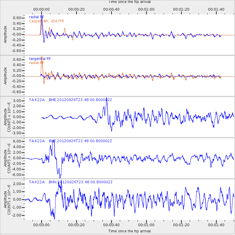
Earthquake location: Andreanof Islands, Aleutian Is.
Earthquake latitude/longitude: 51.6/-178.3
Earthquake time(UTC): 2012/09/26 (270) 23:39:55 GMT
Earthquake Depth: 16 km
Earthquake Magnitude: 6.3 MB, 6.5 MS, 6.4 MW, 6.4 MW
Earthquake Catalog/Contributor: WHDF/NEIC
Network: TA USArray Transportable Network (new EarthScope stations)
Station: K22A Casper, WY, USA
Lat/Lon: 42.65 N/106.52 W
Elevation: 1686 m
Distance: 47.8 deg
Az: 71.039 deg
Baz: 306.901 deg
Ray Param: 0.069738604
Estimated Moho Depth: 12.0 km
Estimated Crust Vp/Vs: 2.10
Assumed Crust Vp: 6.178 km/s
Estimated Crust Vs: 2.946 km/s
Estimated Crust Poisson's Ratio: 0.35
Radial Match: 92.0649 %
Radial Bump: 400
Transverse Match: 67.72337 %
Transverse Bump: 400
SOD ConfigId: 478790
Insert Time: 2013-02-22 23:16:42.927 +0000
GWidth: 2.5
Max Bumps: 400
Tol: 0.001

Signal To Noise

ChannelStoNSTALTA
TA:K22A: :BHZ:20120926T23:48:00.800002Z8.4686439.937798E-71.1734818E-7
TA:K22A: :BHN:20120926T23:48:00.800002Z3.17795783.8622701E-71.2153308E-7
TA:K22A: :BHE:20120926T23:48:00.800002Z2.58987024.960491E-71.9153433E-7
Arrivals
Ps2.2 SECOND
PpPs5.7 SECOND
PsPs/PpSs8.0 SECOND